


The Local newsletter is your free, daily guide to life in Colorado. For locals, by locals.
The pecking order of public lands in Colorado is pretty clear. The national parks and monuments soak up all the glory on account of their high-profile designations. All the other lands come in a distant second: state parks, designated wilderness areas, Bureau of Land Management property, and, maybe least overtly beloved, U.S. Forest Service terrain. After all, you rarely hear someone exclaim, “I can’t wait to go to [insert name] National Forest this coming weekend!”
Clearly, this is just a branding issue, because the truth is that Colorado’s national forests hosted 32.4 million people in 2020, dwarfing the 19.5 million who visited state parks and the 4.4 million who traveled to the state’s national parks. Landmark sites such as the Maroon Bells, in White River National Forest, and Pikes Peak, in Pike National Forest, have a lot to do with that, but there’s something else, too. These stunning landscapes are veritable playgrounds for weekend warriors.

Every single one of the state’s 11 national forests has something special to tout, but only one hops the border to offer contiguous fun in both Colorado and Wyoming: Medicine Bow-Routt National Forests. That quirk of geography isn’t its defining characteristic, though. In fact, there isn’t just one standout attraction; there are dozens.
At its southern end, Routt National Forest unfolds to the northwest of Kremmling and then jumps the invisible line into Wyoming. There, the forest’s name changes to Medicine Bow and splits into four distinct sections, three of which are near the border: the westerly side marked by the Encampment River, the middle singularized by the Snowy Range, and a tiny easterly outpost home to Vedauwoo Recreation Area. With millions of acres of terrain worth exploring, where does one choose to recreate? We’ve got you covered with more than 30 ways to enjoy a summer weekend away from Denver.

Access to Medicine Bow-Routt National Forests
The easiest way to gain entrée to Medicine Bow-Routt National Forests’ many adventures is to purchase an annual day-use pass ($30), available online at recreation.gov. Although many locations are free to access, having this sticker means you won’t have to bring cash or checks to stuff into envelopes at sites with day-use fees.
Four-Wheeling
Wyoming’s Albany Lodge can be home base for a number of activities, but four-wheeling reigns supreme.
Five years ago, David Wright decided he was done with corporate America. He and his wife thought maybe they’d buy a bed-and-breakfast and enjoy a quiet semiretirement. Instead, they purchased 76-year-old Albany Lodge—a nine-room hotel with 14 cabins and a gear rental shop at the edge of Medicine Bow National Forest—and haven’t had a quiet day since.
The noise emanates not only from the guests grabbing a few longnecks at the bar or laughing with friends and family at the on-site restaurant but also from the constant hum of off-highway vehicles. More commonly called side-by-sides, these glorified dune buggies have wicked shocks, knobby tires, and four-wheel-drive capabilities perfect for off-roading on the more than 500 miles of trails in Medicine Bow National Forest. “We are a ride-in, ride-out facility,” Wright says, adding that roughly 50 percent of summertime guests hail from Colorado. “The lodge offers easy access to a good mixture of trails, from beginner to advanced.”
With that in mind, we asked Albany Lodge operations manager Jake Hauschildt to recommend some of his favorite paths. These three off-road trails, all of which are accessible right from the lodge, made the cut. —Lindsey B. King

Beginner
The route: Follow National Forest System route 500 for roughly 15 miles. Then, take route 512 another 15 or so miles to the banks of the North Platte River.
Hauschildt says: “This 30-mile out-and-back stays on well-maintained, easy paths. There’s some elevation loss—about 1,000 feet—as you go down to the river but nothing too crazy. As you get close to the water, you can see the burn area from the Mullen fire in 2020. If you like to fish, bring a rod, because there’s some good fishing down there, too.”
Intermediate
The route: Roll along route 500 for about two miles. Go right on 305 and travel roughly eight or nine miles until coming to 338; take it. Another eight or nine miles will bring you to 307, which you’ll follow until it dead-ends. Then turn around.
Hauschildt says: “This route is a little bit more technical, meaning you’ll need to reduce your speed in parts to crawl over rocks. It’s not too intense, but you’ll get to drive the machine—see what it can do. Along 307, you’ll see some great views of the Centennial Valley, a waterfall, and the old Queen Mine from the 1920s.”
Advanced
The route: Begin the loop with a nine-mile stretch on 500 before heading right onto 555. After 10 miles, hang a left on 336, then drive 10 more miles to reach Libby Flats. Keep going five more miles on 336, until you go right onto 275, which will spit you back out onto route 500, leaving you with a 20-mile ride back to the lodge.
Hauschildt says: “Although it isn’t holy-cow crazy, this route has a lot of elevation change and some whoops [aka dips] in the trail. When you reach Libby Flats, get out of your side-by-side to go up to the observation deck. Route 275 runs parallel to French Creek, and there are standing puddles and rocky parts that are fun to drive through.”
Climbing

Back to Top
Masochists the world over flock to Medicine Bow’s Vedauwoo Recreation Area to practice an arduous form of climbing.
The pursuit of crack climbing requires the shoving of fingers, fists, and entire bodies into seams in the stone, a brutal blend of friction and balance propelling practitioners skyward. “There’s an initial awkward stage,” says Zach Lentsch, who owns climbing instruction company Wyoming Mountain Guides in Thermopolis. “But once you power through, you learn all these techniques that open up a whole new world of climbing.” Unlock this painful but oddly addictive Pandora’s box at Wyoming’s Vedauwoo, a famed climbing area in Medicine Bow’s southeastern region that boasts more than a thousand routes—including these four increasingly challenging recommendations from two frequenters of the “Voo.” —Angela Ufheil
Le Petit Arbre
Try It For: Learning The Ropes
Most Vedauwoo routes require traditional climbing, an advanced style in which climbers install temporary anchors as they ascend, to catch them should they fall. Not so for this 90-foot-tall route near the Lower Blair I area, says Tyler Grabner, a board member for the volunteer organization Southeast Wyoming Climbers Coalition, which works to maintain climbing access in Vedauwoo while also protecting the land. Those not comfortable with using their own safety equipment can secure a rope to a pre-installed anchor—you’ll scramble in from a different direction—located midway up the rock. That top-rope allows newbies to practice basic crack-climbing technique, minus the stress of anchor placement.

Moor’s Crossing
Try It For: Perfecting Skills
On one section, only your fingers might fit into the split in the rock. On the next, you could be wedging your entire body into the gap, inching upward using a tactic called “chimneying.” Such is the nature of this intermediate route, one of Lentsch’s favorite climbs, on Reynold’s Hill. “Moor’s Crossing involves the widest variety of techniques on a single climb I’ve ever experienced,” the guide says. Take a break near the top of the crag, which, at 250 feet tall, gives climbers a “hello down there” vantage point for watching Middle Crow Creek wind through the area.
Sore-O-Pod
Try It For: Gaining Poise
Also called Spatial Juxtaposition, Sore-O-Pod—Grabner’s pick for intermediate climbers who want to test their technique and their mettle—is approximately 60 feet in length. “Sore” is in its name for a reason. The first section involves a steep, hand-size crack that even Grabner admits can look too tiring to send. Still, “if you kind of feel around, there are good holds inside the crack,” he says. Figuring out that trick is only your initial challenge on this hunk of rock in the Jurassic Park area, though. After that, the gap widens enough to fit your entire forearm, an uncomfortable move called an arm bar. Prepare for bruises.
Spectreman
Try It For: Showing Off
First, picture two walls meeting at the corner. Next, imagine that corner has a crack running up it. Oh, and one more thing: The route’s overhang forces you to lean back slightly as you drag yourself up. Those multiplying challenges attract advanced climbers to this popular 70-footer near Upper Blair. With a rating of 5.11, Spectreman isn’t the most difficult climb here, but unless you’re a professional, Lentsch doesn’t recommend trying anything tougher.
Before You Go
Websites such as Mountain Project and vedauwoo.org, a page maintained by local climber Skip Harper, can help you discover your preferred route. But we recommend taking a crack climbing crash course with a local guide service like Lentsch’s or through Colorado Mountain School to learn safe techniques and best practices for protecting the rocks you love to scale.
Hiking
Back to Top
Hiking the 10-mile Zirkel Circle is a Steamboat Springs rite of summer. Here’s how to loop the six-hour route—absolutely rife with gorgeous scenery—like the locals do. —Kelly Bastone

600 feet in
After following Gilpin Lake Trail out of the Slavonia trailhead, your first landmark is the junction with Gold Creek Trail (#1150). Follow it off to the right: Hiking counterclockwise sets you up for the most impressive views of Gilpin Lake.
2 miles in
Crossing Gold Creek is always thrilling. This stream rages with snowmelt in early summer, and because wilderness restrictions prohibit the construction of a pedestrian footbridge, hikers must ford the stream (only viable in late summer to fall) or test their balance by walking across a log that spans the 10-foot-deep chasm.
3 miles in
Eight-acre Gold Creek Lake is ringed with conifers. Scan those treetops for bald eagles that perch in the heights, eyeballing the water for dinner-worthy trout.
4.4 miles in
Turn left onto Gilpin Lake Trail (#1161) to continue ’round the loop. Or, if you’re a peakbagger, stay on #1150 to Red Dirt Pass Trail (#1142) and follow the track to the 12,185-foot summit of Mt. Zirkel.
6 miles in
Vistas abound from a subalpine saddle at about 10,775 feet: The dominant peak to the north is 12,059-foot Big Agnes, namesake of the well-known Big Agnes brand of camping gear based in Steamboat Springs. The rest of the Sawtooth Range clusters around the mesmerizing, craggy mountain, while 29-acre Gilpin Lake fills the rocky basin below.
7 miles in
Toting a fishing rod? Gilpin Lake’s 60-foot depth is ideal for big trout. Cast for these hogs from the rocky southwestern shore.
7.75 miles in
Another opportunity to don those water sandals you’re schlepping presents itself; Gilpin Creek isn’t as deep or as pushy as Gold Creek, but it’s just as frigid.
8.5 miles in
After your time above 10,000 feet, the mixed conifer forest here feels positively tropical. Look for scarlet paintbrush and other sun-loving wildflowers.
9 miles in
The trail (#1162) to Mica Lake (four miles, one way) joins your route from the right. Continue on #1161, but only after departing it momentarily for a scramble up the massive boulder (dropped here 10,000 to 30,000 years ago) that sits to the south of the junction.
9.5 miles in
The trail’s final mile swerves away from Gilpin Creek. As you finish the hike, keep an eye out for thimbleberry bushes. Look-alikes to raspberries, these ruby red fruits peak in late July and taste like rhubarb pie.
Mountain Biking

Back to Top
About a decade ago, Steamboat Springs retrofit its “Ski Town USA” nickname to include bikes—and for good reason.
Bike Town USA is surrounded by parts of Routt National Forest that include an expansive network of hiking trails fat-tire enthusiasts have been exploiting since the early ’90s. Then, trail-loving locals approved a 2013 ballot initiative that started using existing lodging tax revenue to build new routes for hiking and mountain biking. Now, purpose-built singletrack rounds out the old-school paths that plumb remote mountain meadows. So whether you’re looking to rail banked corners or shoulder your bike over gnarly cliffs, Routt National Forest near Steamboat has something for you. —KB
If you like: Stairways to heaven
You’ll love: Hot Springs and Lower Bear trails
Location: Mad Creek trailhead, seven miles north of downtown
Because: The climbing may be constant, but the scenery is varied, combining bucolic cattle meadows, streamside conifers, and bald knobs showcasing on-high vistas toward the Steamboat ski area. Your warmup is 616 feet of vertical on 2.5-mile Hot Springs Trail, followed by a short grunt up Strawberry Park Road to Lower Bear Trail, which gains nearly 1,000 feet over two miles to the high point. The return descent is fast and loose: Watch your traction on the pea gravel corners.
Need to know: Strawberry Park Hot Springs sits between the two trails, but remember that reservations are required.
If you like: An all-you-can-eat buffet
You’ll love: The big North Routt loop
Location: Pearl Lake State Park, 27 miles north of town
Because: Drive 45 minutes north of town and you can stitch together a 39-mile lollipop loop combining all of this region’s rugged, old-school singletrack, including Pearl Lake, Coulton Creek, South Fork, Diamond Park, and Scott’s Run trails. Expect a pristine backdrop, solitude, and a few hike-a-bike segments that underscore the unmanicured nature of this far-flung route.
Need to know: In early summer, riders are likely to encounter lots of downed trees across the trails and raging water when fording the South Fork of the Elk River.
If you like: Having to don battle armor
You’ll love: Grouse Trail
Location: Dry Lake trailhead, six miles northeast of town
Because: This three-mile descent challenges your skills—and your nerve—with its rock medley. There’s loose rock, ledgy rock, cliffy rock, rock rolls, and “gotcha” rocks. When you can safely tear your eyes away from the trail, you’ll look out over plunging valleys and panoramas of rounded summits. But the real reward is that chest-thumping surge of triumph that comes from conquering the gnar.
Need to know: Ask a buddy to shuttle you to the top of Grouse, or pedal about five miles from the Dry Lake trailhead. Local hardbodies create a 20-mile out-and-back from town via Spring Creek Trail.
If you like: Family adventures
You’ll love: Panorama Trail
Location: Dry Lake trailhead, six miles northeast of town
Because: This one-mile loop serves up all kinds of visual stimulation—think fluttering aspen leaves and colorful wildflowers—without the suffering of longer, more technical routes. Smooth and gently graded, it’s ideal for families with kids.
Need to know: More smooth-and-easy mileage awaits on nearby Fiddlehead (a two-mile loop) or Flash of Gold (five miles one way).
Fly-Fishing
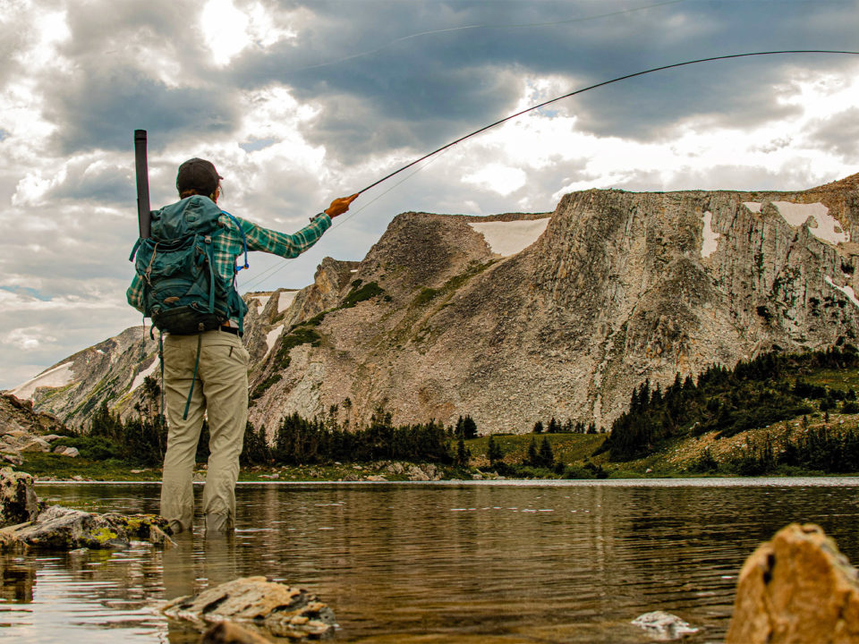
Back to Top
Chasing golden trout in Medicine Bow’s Snowy Range.
My screen-dominated life feeds me a steady parade of photos, most of them forgettable. But a couple of years ago, my eyes swiped across an Instagram picture of somebody holding a golden trout, and I felt a surge of envy: I want that. So, when I learned that some lakes in the Snowy Range hold goldens, I loaded up my fishing gear.
Golden trout are native to the Little Kern River system of California. Over time, people have transplanted them into other U.S. watersheds, including the lakes of Wyoming’s Wind River Range, where a record-setting two-pound golden was caught in summer 2021. I didn’t care about size: I just wanted to see those blazing orange scales. Sadly, the Wind River Range is a five-plus-hour drive from my Steamboat Springs home. To my greed-fueled delight, though, U.S. Forest Service maps of the Snowy Range in southern Wyoming show that Shelf Lake #1 and #2 hold only golden trout.
Encouraged by a shorter drive, I started the two-mile hike one brisk September morning with my husband and daughter. The trail passes through some truly stunning scenery, but everything seemed extra beautiful to me because I knew it to be the land of living gold.
Topping out at Shelf Lake #1, we waited scarcely a minute before we saw a fish slurp something off the surface. We scrambled onto the boulders beneath a cliff wall where the water depth dropped off sharply. On my third cast, I felt a tug. I didn’t wait to issue my celebratory hoot…except the fish I reeled in wasn’t golden. I was befuddled.
The nine-incher had a pink stripe down the side and a pale white belly, much like a rainbow. We snapped a perfunctory photo. Maybe the Forest Service maps were wrong? Maybe someone had introduced another trout species to the lake? Or maybe, I thought, the real golden trout awaited us at Shelf Lake #2.
A 10-minute walk over relatively flat ground brought us to that neighboring shore, where we saw a school of 12-inch fish browsing in the shallows, though they looked just like the specimen I’d hauled out of the first lake. We caught bunches of them and hooked into one bigger swimmer that might’ve flashed some gold. We’ll never know for sure, though, because it shook the hook. Everything we palmed was starved of color. Despite the lively action, I felt let down.
Back at home, I looked at the photo of the fish I’d caught. Its spots stopped near the tail, whereas the spots on a rainbow trout would’ve extended across the entire back and sides. And there were dark green splotches that definitely weren’t rainbowlike. What in the hell had I caught?
Bobby Compton, fisheries supervisor for Wyoming Fish and Game, knew exactly what had taken my fly. I learned that the Shelf Lakes do indeed contain golden trout; they are stocked every other year. But stocker goldens don’t start out with those famously golden hues. Without rivers to spawn in (the lakes are fed by snowmelt), the stockers may not develop deep color, since it is thought to be associated with mating, age, and size.
Gilded or not, I’d caught golden trout, and that should’ve been enough to thrill me, given their rarity. Even without crazy oranges, they’re beautiful. Instagram may be a crappy field guide, but goldens—in all their guises—are worth the chase. —KB
Scenic Byway
Back to Top
Topping out at 10,847 feet, the Snowy Range Scenic Byway (WY 130) runs east-west across the middle segment of Wyoming’s Medicine Bow National Forest and takes Sunday drivers for a spectacular ride. Leaving from Laramie, headed west on I-80, explorers will follow signs to pick up the 29-mile stretch of pavement that ribbons its way through stunning valleys and high-elevation meadows and past alpine lakes and soaring peaks. For those inclined to get out of the car, there’s plenty of backcountry adventure to be had; however, the byway is remarkable for the views it bestows upon those who are satisfied to window shop. Don’t miss these 12 pit stops, points of interest, and proposals for finding fun along the way. —LBK

1. Vee Bar Guest Ranch
During the summer, this lodge provides three- and six-night all-inclusive, dude-ranch-style vacations. On Saturdays from early June to early September, however, Vee Bar offers a bed-and-breakfast option ($220).
2. Mountain View Historic Hotel & Cafe
Built in 1907 and located in the tiny hamlet of Centennial, the Mountain View has several overnight accommodations, but just popping into the cozy coffeeshop for a cup of joe and a pastry is a great way to fuel up on an early morning excursion into Medicine Bow.
3. Centennial Visitor Center
Generally open from Memorial Day well into October, the center is staffed with rangers—who actually answer the phone (307-742-9730)—Thursday through Monday from 9 a.m. to 5 p.m. It also has maps, brochures, and a vault toilet.
4. Barber Lake Road
This winding road requires a five-mile detour off the byway, but it’s worth the side trip to see some of the campgrounds, babbling Libby Creek, and lovely foliage during the fall.
5. Brooklyn Lodge
A cozy log cabin getaway is what we all need. This one—designated on the U.S. National Register of Historic Places—can be rented as a vacation home or booked as a bed-and-breakfast (prices vary depending on type of stay).
6. Brooklyn Lake Road
A small offshoot conveys water lovers to Little Brooklyn and Brooklyn lakes (there’s also a campground and parking area here). A network of trails leads to other lakes, including the two Glacier Lakes, which are only about 0.75 miles from the trailhead. Driving back out of the area, hang a right onto Forest Service Road 332, which passes several other bodies of water before rejoining WY 130.
7. Libby and Lewis Lakes Picnic Areas
Pack a sack lunch so you have an excuse to linger at a table or bench near one of these two mountain jewels, which sit at the base of 11,398-foot Sugarloaf Mountain. A trailhead here leads to more than 80 lakes as well as to the summit of 12,013-foot Medicine Bow Peak.
8. Libby Flats Observation Area
The high point of the byway at Libby Flats is home to a stone observation station that overlooks the national forest as it spreads out faaaaaar below. The winds can really rip up here; a jacket and hat are a good idea, even in the summer.
9. Snowy Range Observation Point
As you round the bend headed west from Libby Flats, get ready for eyeball-popping views of the Medicine Bow Mountains. The vantage point from the observation area is almost vertigo-inducing, as jagged summits meet you at near eye level. For those who aren’t able to hike deep into the backcountry, this may be one of the most accessible, up-close, jaw-dropping views of high peaks in the West. Note: A short loop trail with interpretive signs leads from the parking lot to the old Red Mask Mine.
10. Mirror Lake and Lake Marie
This spot puts the scene in scenic byway. On clear, calm days, these two large glacier-fed lakes that sit at the base of Medicine Bow Peak reflect Instagram-ready images of the mountains that your followers won’t believe. Both lakes are stocked with brookies, rainbows, and cutthroat. Simply put: The lakes are heaven for anglers (who need a fishing license; a five-day, nonresident license is $56) and stand-up paddleboarders. There are restrooms and picnic tables, too.
11. Snow Survey Cabin
Although this one-room U.S. Forest Service cabin doesn’t have running water or any creature comforts, it does provide bunk beds for four and a location that can’t be beat for access to hiking trails, lake and stream fishing, and wildlife viewing. Book the cabin ($50 per night) through recreation.gov.
12. Ralph Heston Viewing Platform
The little pier over French Creek is a great spot for the kids—or you!—to get a line wet. The wooden jetty helps the littles reach the water more easily. Just make sure to buy a Wyoming fishing license before unstowing your rod.
Gravel Biking

Back to Top
A multiday, supported gravel-bike adventure offers a deep dive into Routt National Forest.
I’ve been biking for six hours across northern Colorado’s Routt National Forest. I’ve climbed almost 6,000 feet, from the grasslands to the foothills, from aspen groves to the dark timber, and through a couple of real-deal cattle drives. I’m on a bike with tires skinnier than those on my mountain bike but wider and more forgiving than my road bike tires. I’ve eaten thousands of calories in dried fruit, nut butters, baked goods, and sandwiches. My legs ache, and I’m dreaming of icing them in a cold mountain lake and lying down in my tent before a catered dinner. I’m trying not to think about what the next three days of riding might hold and whether my legs are up to the challenge.
The Ramble Ride, founded in 2016, is one of thousands of organized gravel events around the country, many of which sell out within days. Before July 2021, I had never ridden a gravel bike. I had also never covered 234 miles and close to 20,000 vertical feet on a bike in four days. As an avid road and mountain biker, though, I thought the four-day journey might be a fun challenge. Plus, Ramble Ride founder Peter Discoe warned me and some 60 other participants that “you’ll ride more than you think but never more than you can.” Discoe knows of what he speaks. He started riding in the area in 2011 and discovered thousands of miles of scenic gravel roads skirting the Wyoming-Colorado border. After 20 people joined him on a 225-mile ride from Fort Collins to Steamboat and asked him to plan another trek the following year, he wondered if he could turn his talent for organizing group rides into a business. He wrote a plan, found partners, scouted routes, applied for permits—and created the Ramble Ride.
The first morning, at 7, Discoe’s wife, Christine, and her team of Ramble volunteers serve breakfast sandwiches and coffee under a tent next to the town park in Walden, where most participants camped the night prior. This historical ranching town northeast of Steamboat Springs with fewer than 600 people welcomes Discoe’s events each year. I’m on a bike equipped with frame bags to carry my day gear. During the first 65 miles, I encounter everything from rolling, desolate dirt roads to steep, rocky climbs. Some of the miles click by; others are hard-earned. No matter my pace, there is always a rider or two to pedal with and share breathless conversation.
When I roll into our group campsite late in the afternoon, the beer is chilled, the snacks are plentiful, and the kitchen crew is preparing something that smells delicious from a mobile kitchen. I set up my tent near Big Creek Lake, go for a swim, and stretch before dinner, when everyone loads their plates and finds a seat within earshot of Discoe’s debrief of the day and preview of tomorrow’s adventure.
It’s a routine I settle into for three more days—early departures from lakeside campsites that turn into challenging and interesting rides through rarely visited mountains and lonely ranching towns. I’m astounded at how these roads are seemingly constructed for bike travel. The terrain rolls gradually up and down manageable foothills and mountains, following winding river valleys and undulating ranchland. Each evening, I relax into a happy exhaustion, enjoying the lack of cell service and falling asleep to the sounds of waves lapping the lakeshore, knowing I have nothing to do tomorrow but ride. —Tess Weaver
Ramble Rides in 2022
June 22–25: Women’s Ramble
July 13–16: Summer Ramble
August 31–September 3: Summer Ramble 2
September 28–October 1: Fall Ramble
Rates start at $900
Backpacking and Paddling
Back to Top
The 16-mile Encampment River Trail runs along an enchanting waterway, offers magical views, and delivers a back-of-beyond feel ideal for a backcountry camping trip.
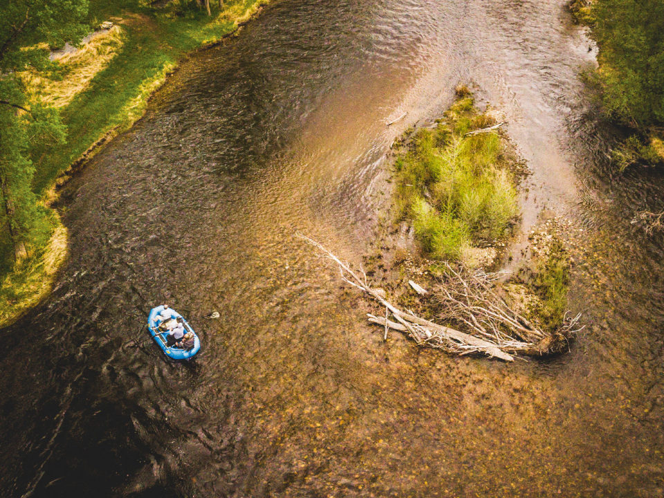
The main attraction of Wyoming’s smallest designated wilderness area, the Encampment River Trail runs the length of an uncompromising canyon that stretches from Odd Fellows Campground near the town of Encampment to the Commissary Park trailhead on the Wyoming-Colorado border. Backpackers can start their treks at either end, but unless they’ve left a vehicle at their destination, this 16-mile journey turns into a 32-mile haul. Not that that would be a bad thing: A three-day, two-night, primitive-camping backpacking trip gives adventurers time to get a line wet for browns, brookies, and ’bows; search the cliffs for elk and bighorn sheep; and explore the remnants of old cabins and mining operations. The best spot to pitch a tent along the trail comes roughly 5.5 miles in from Odd Fellows Campground, but there are other flat spots along the way that will suffice. Hikers should be prepared for several knee-high creek crossings (water shoes aren’t a terrible idea) and possible deadfall along the trail.
The Encampment River toggles between turbulent and placid as it runs through its namesake canyon and adjacent to the trail. The upper section is steep and narrow and is only navigable by expert kayakers, as it’s full of Class III and IV rapids and a few Class V drops. A lower section, from the Encampment River trailhead to Baggot Rocks, is beautiful and raftable, although you’ll need your own boat (there aren’t many outfitters around), decent paddling skills, and an awareness of private property laws. Hikers along the trail can ogle the waterway, get their feet wet in myriad spots, and watch boaters—some carrying anglers—as they float past. —LBK


