The Local newsletter is your free, daily guide to life in Colorado. For locals, by locals.
Length: 2+ miles round-trip
Difficulty: Easy, although some scrambling and extreme caution are required if you want to climb to the top
Why we love it: This hike features one of the best views in Colorado Springs.
When to go: Any season, although it’s best to avoid the mid-day heat in summer and snowpacked trails immediately after a winter storm
Pre-hike buzz: The nearby family-owned Blue Mountain Creamery serves espresso drinks, as well as sweet treats like house-made gelato.
Restrooms: None
Distance from Denver: About 65 miles
Dogs: Allowed
When the Rocky Mountains rose about 65 million years ago, erosion produced a lot of sand and gravel that rivers transported to the Great Plains, where the debris was spread far and wide, gradually raising the Plains’ elevation to the height of Monument Pass between Denver and Colorado Springs. Beginning about 5 million years ago, however, the geologic mode switched from sediment deposition to erosion, and Monument Creek, which flows south from the town of Monument to downtown Colorado Springs, began to eat away at this stack of loosely cemented rock. This activity has created the broad valley that I-25 uses to climb up to Monument Pass from the city of Colorado Springs, as well as the Austin Bluffs, a higher mesa that rises above the city to the east.
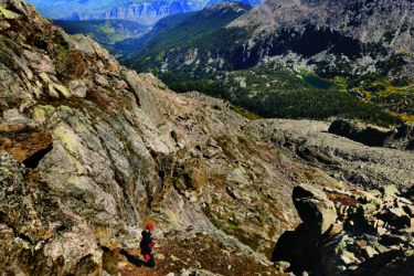
Pulpit Rock is a resistant outlier of the Austin Bluffs that, thanks to its elevation, offers a panoramic view of the city with Pikes Peak in the background. The view is especially captivating in the morning, when the mountain is bathed in the sunrise glow.
Pulpit Rock Park is connected to the Austin Bluffs Open Space, so you can wander around the mesa for as far and as long as you like. A good objective is to circle around Pulpit Rock, taking a short detour to ascend to the summit and enjoy the scenic view.
From the trailhead, begin walking along the main dirt road. If you’d like to climb to the summit, after about 300 yards, you must branch off the road to the right on any one of the numerous unmarked social trails. Aim for the saddle that connects Pulpit Rock to the mesa east of it. The slopes get progressively steeper near the top, but you should reach the saddle in 15 to 30 minutes. From the saddle, head west along the ridge, winding your way around the series of small rock towers that guard the summit. The easiest path lies just right (north) of the ridge crest.

Getting to the true summit requires a very short scramble using your hands, but the view is equally good from a flat shoulder to the right. No matter which route you choose, exercise extreme caution and do not approach the cliff edges. Pulpit Rock is surrounded by steep dropoffs, especially to the south, and the rock is crumbly and unreliable.
From the top, the stunning view stretches from south of Pikes Peak to the flat-topped Rampart Range high above Monument, with the city of Colorado Springs sprawling in the foreground. Once you’ve taken it all in, you can (carefully) descend the rock and return to your car, or complete the loop around the rock. To do so, retrace your steps down the summit ridge and continue east along the ridge crest toward the Austin Bluffs mesa. Here, another series of unmarked social trails crisscross the area, so you can pick your way down the south slopes on whichever trail best suits you. Once you reach the gentler terrain, veer right at each fork to stick close to the rock. Soon, you’ll find yourself back at the trailhead after an enjoyable (and remarkably solitary) two-hour walk.
Getting there: From Denver, take I-25 south to Exit 148. After exiting, turn left onto Nevada Avenue, which passes beneath the interstate. At 0.7 mile after the exit, turn left at the light by the University of Colorado-Colorado Springs sign. In 0.1 mile you’ll arrive at a secondary trailhead marked by a rough dirt parking lot on the south side of the BMW dealership. Park here or proceed another half mile south on North Nevada Avenue to a second lot on the right next to an electrical transformer. This is the main trailhead and the point where the trail directions begin.