The Local newsletter is your free, daily guide to life in Colorado. For locals, by locals.
Length: 16.5 miles, one way
Difficulty: Challenging
Trailhead: Lehigh Connector (39.96475, -105.25373)
Shuttle car: Goat Path (40.03286, -105.29270)
Why we love it: Decide for yourself which mountaintop serves up the best views over Boulder when you travel across the city’s skyline, hitting all five high points.
When to go: Year-round, but beware summer thunderstorms. In wintry conditions, pack traction devices.
Pre-hike fuel: Grab a cup of joe and a breakfast sammie to go at Moe’s Broadway Bagel on your way to the south Boulder trailhead.
Post-hike buzz: A northbound traverse deposits you at the base of Mt. Sanitas, where you can replenish lost calories over pub grub at the nearby Hungry Toad. If you shuttle back to your car at the Lehigh Connector trailhead, a pit stop at the Southern Sun is a perfect capstone to a Boulder adventure: Order a bowl of Jerry’s chili and a large basket of fries, throw them together, and enjoy over local IPAs.
Restrooms: Don’t expect legitimate facilities until you reach Flagstaff Mountain and Mt. Sanitas on the backend of the hike.
Dogs: Allowed

Even locals brag about this one: The Boulder Skyline Traverse hits all of the city’s loftiest peaks on one mega adventure above town. That’s 16.5 miles—one way—and more than 12,000 feet of elevation change. But for folks with the time and gumption for an epic, there may be no greater feat in Boulder than roller-coastering across its horizon in one go.

Technically “nontechnical,” the Boulder Skyline Traverse doesn’t require special equipment or know-how—it’s a pure hike. But don’t go in unprepared. The initial climb to the top of 8,459-foot Bear Peak is a doozy, gaining roughly 3,000 feet of elevation in just three miles. The traverse itself also necessitates precise navigation skills, as hikers link dozens of foot paths and social trails to create the route, including one off-trail section near Flagstaff Mountain. In other words, pack a map and compass, and know how to use them. Finally, don’t get caught on a bare ridge or peak in inclement weather.
Ready to go for it? Drop a shuttle car off at the Goat Path trailhead on Forest Avenue, off the eastern flank of Mt. Sanitas. (No spare car? No worries: You can also work the SKIP bus from Broadway and Forest near the end of the hike to Greenbriar and Gillaspie, the beginning.) Then head down to the Lehigh Connector trailhead on Greenbriar Boulevard. Though it’s not a true south-to-north traverse, logistically it makes most sense to bag 8,459-foot Bear Peak first, then head south to 8,514-foot South Boulder Peak before yo-yoing back north.

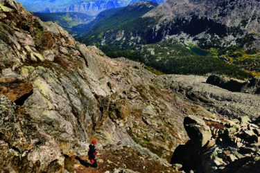
To start, link the Lehigh Connector and North Fork Shanahan Trail to Fern Canyon. Climb up, up, and away through the boulder-choked canyon, gaining roughly 3,000 feet over three hard-earned miles, to break above the forest. From the ridge, first bag 8,459-foot Bear Peak (some hand-over-hand climbing required to reach the tippy-top) before continuing off its back slope across the Shadow Canyon saddle to high point 8,514-foot South Boulder Peak near mile 3.6. In clear conditions, pinpoint your favorite Boulder landmarks (the rust-colored shingles of university buildings and the shimmery surface of Baseline Reservoir) before ID’ing the Mile High City to the southeast.
Retrace your steps off South Boulder and past Bear to downclimb the twin mountains via the Bear Peak West Ridge Trail, which wends through a burn area (wide views into the Indian Peaks Wilderness) to Bear Canyon Creek. (Have a filter? Top off water here.) Pick up the Green Bear Trail, which ascends through a pine forest to intercept the Green Mountain West Ridge Trail. Top out on 8,148-foot Green Mountain near mile 8.3, where a summit block identifies prominent points you can spy in the Indian Peaks and Rocky Mountain National Park on a clear day.
Back on the Green Mountain West Ridge Trail, split north onto the Ranger Trail, which descends through dappled pines all the way to Realization Point, a famous amphitheater off Flagstaff Road. Here’s where it gets tricky: Link the Ute Trail with various unnamed social paths to “summit” 6,983-foot Flagstaff Mountain, less a peak than a wooded mound. Type A hikers will want to use a GPS device to cross the true high point (near 40.00176, -105.30764 or so) around mile 10.3 overall before reconnecting with the Ute Trail.
Continue northeast on the Ute Trail to find the Flagstaff Trail, which zigzags east off Flagstaff Mountain, crossing the main road a handful of times. Pass Panorama Point, another scenic pull-off for vehicles, before picking up the Viewpoint Trail, which descends into town to the Boulder Creek Path. Navigate past a park and across Canyon Drive to link up with the Red Rocks Trail. Hike past the eponymous boulders and into Sunshine Canyon, at the southern flank of the final peak: 6,800-foot Mt. Sanitas.
Haul tired legs up the main trail, affectionately referred to as the Stairclimber by locals: This final push gains roughly 1,240 feet over 1.3 miles (and passes four false summits) to the high point. Take in your final vista before descending Mt. Sanitas via the East Ridge Trail and Goat Path, which deposits you at Forest Avenue and your blessed shuttle car. We assume you left yourself a celebratory beer?

Getting there: From Denver, take I-25 north to U.S. 36 west. Take the Baseline Road exit toward CO-93. To drop a shuttle car off, first take Broadway north to Evergreen Avenue; turn west (left) and follow Evergreen 0.5 mile to 4th Street. Veer north (right) onto 4th for one block to Forest Avenue. Park near its terminus at 3rd Street. Next, navigate back to Broadway and follow it 3.9 miles south to Table Mesa Drive. Turn west (right) onto Table Mesa and continue 0.7 mile to an intersection. Veer south (left) onto Lehigh Street and drive another 1.2 miles to the trailhead.