

The Local newsletter is your free, daily guide to life in Colorado. For locals, by locals.
- Length:
- 5.3 miles (loop)
- Difficulty:
- Easy
- Trailhead:
- White Ranch Park West (39.818665, -105.286423)
- Why we love it:
- It’s a quick, kid-friendly getaway without crowds—and with a scenic view of downtown Denver’s skyline.
- When to go:
- Year-round, but the trail is subject to seasonal closures due to muddy conditions. Check the Jefferson County Parks & Open Spaces website before you go.
- Pre-hike fuel:
- Indulge in Cafe 13’s fully loaded avocado toast (sourdough piled high with fresh avo, two eggs, candied bacon, everything bagel seasoning, greens, and a squeeze of lemon).
- Post-hike buzz:
- Cool down with a New Zealand–style ice cream cone (fresh fruit blended to order) at Happy Cone inside the Golden Mill food hall, whose spacious patio is great for dogs and kids.
- Restrooms:
- Compost toilets at the trailhead
- Dogs:
- Allowed on leash
Sometimes the best hike is the one that’s less than 30 minutes from your house. My husband and I once bonded over ambitious backpacking trips, and one day we will again—but with a six-month-old who’s not yet sleeping through the night, and a distractible three-year-old who detours for every mushroom and squirrel, we are firmly in our “just get outside somehow” era. On a Friday afternoon, we finished work a little early, tossed the hiking carrier in the car, and headed to White Ranch Park.
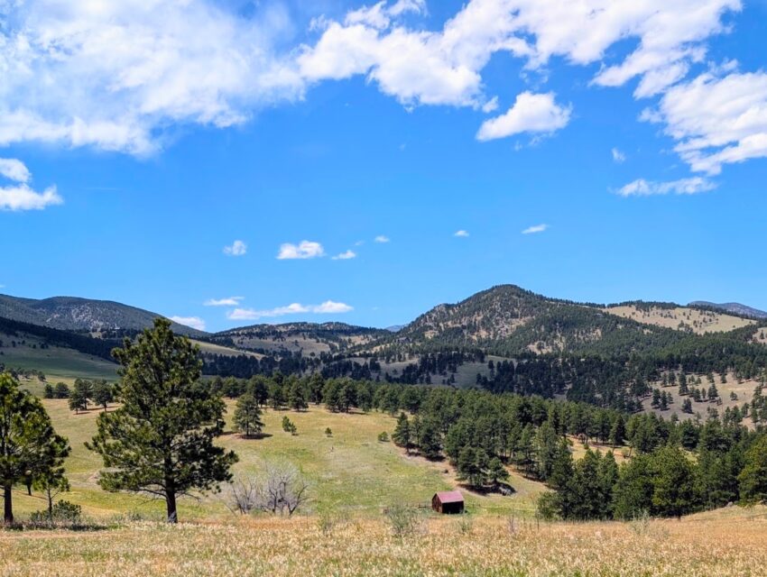
With 3,953 acres and 21 miles of trails, this sprawling space is the largest preserve in the Jefferson County Parks system. The East trailhead is closer to downtown Golden and thus gets more visitors, but if you venture 11 miles farther up Golden Gate Canyon Road, you’ll be rewarded with peace and quiet. (We only saw one other hiker and a few mountain bikers on our Friday-afternoon visit.) If you’re coming to cycle, head to the Longhorn Trail, a mile of which is reserved just for you, no pedestrians allowed. Horses are also permitted on the trail, which has well-maintained hitching posts and paddocks, so be careful not to step in any scat.

You don’t even have to leave the parking lot for sweeping views of both the Denver skyline and nearby North Table Mountain. Kids and history buffs in your group will enjoy checking out the rusty, 100-year-old farming and ranching equipment on display—remnants of the park’s past as a cattle operation. The Bond and White families ranched here from 1865 until 1974, when they gave the land to JeffCo Parks.
If you’re hiking on a hot, sunny day, consider starting north on the Rawhide Trail; tackling the loop counterclockwise offers immediate shade and a downhill start. For the first mile, you’ll cruise through a series of wide-open meadows reminiscent of The Sound of Music and shaded pine groves on long, leisurely switchbacks.
A mile in, you’ll arrive at the junction with the Wrangler’s Run Trail. To complete the full loop, continue north on the Rawhide Trail. The rolling path ultimately gains about 850 feet of elevation, but well-placed benches along the way with views of the nearby Ralston Buttes offer a nice place to rest your legs. Then, skirt the edge of the Sourdough Springs Campground (or hop on the Waterhole Trail to access the campground’s toilets, if nature calls) before you head back south toward the trailhead.
If you have a fussy baby in tow, like we did, shorten the excursion to a three-mile jaunt by hanging a hiker’s left at the first junction and picking up Wrangler’s Run Trail. Here, the path spills into an expansive meadow where white daisy fleabane, purple wild bergamot, and—my favorite—bubblegum-pink mountain ball cacti bloom in May and June.
After a 0.3-mile shortcut through the flowers, Wrangler’s Run reunites with Rawhide Trail. Veer left to head back to the trailhead but remember, you already got to enjoy the downhill, so this section will be a gentle uphill climb back to your car. Along the way, I stopped to nurse the baby on a tree stump and enjoyed an unexpected aerial show: a mob of 10 ravens, swooping and diving as they drove away a red-tailed hawk. Despite the incline, it was an easy stroll back to the trailhead, where the clouds parted to finally reveal that panoramic view of the Denver skyline.
Not bad for a quick escape on a weekday.
Getting there: From Denver, take I-70 west to Exit 265 toward Golden. Head west on CO 58 for 4.7 miles, then turn right onto CO 93 north. After 1.4 miles, turn left onto Golden Gate Canyon Road. Just about four miles down the road, turn right onto Crawford Gulch Road (where we lost cell service). Turn right onto Belcher Hill Road right after the fire station, and the trailhead is about two miles down the road.


