The Local newsletter is your free, daily guide to life in Colorado. For locals, by locals.
Trailhead Elevation: 9,413 feet
Summit Elevation: 13,468 feet (Ridgway), 13,492 feet (Whitehouse)
Hiking Distance: 11.3 miles, round trip
Time: Full-day hike
Drive Time from Denver: Approximately 6 hours
Closest Town with Services: Ridgway
Where to Park: Wilson Creek trailhead, off Forest Road 852
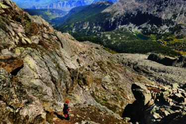
The Hike: Along with their neighbor Mt. Sneffels, Mt. Ridgway and Whitehouse Mountain are visible from dozens of miles away, rising out of the high desert as the first introduction to the San Juan Mountains for anyone driving south. The two peaks use the same approach up the Beaver Creek drainage to the saddle between them, which makes them easy to combine. Peak-baggers rejoice: You get two peaks for the price of one (admittedly long) hike.
From the trailhead, follow the Dallas Trail west and south to Ridgway Hut (bookable through the San Juan Huts). At the first switchback above the hut, head off-trail to the east, navigating blowdown—stretches of fallen trees jumbled like pickup sticks—for a couple hundred yards to a ridgeline climbing to the south. Look for game trails up this ridgeline. Where the ridge ends, continue south then east, traversing the hillside through more blowdown punctuated by open slide paths until you reach Beaver Creek and the trees begin to disappear near 11,000 feet. Head up the obvious scree-choked gully toward the saddle, located at roughly 12,900 feet between Ridgeway and Whitehouse. It doesn’t really matter which peak you conquer first.
To summit Whitehouse, look for another smaller rock-strewn gully that heads east through the cliffs surrounding the flat-topped summit. Climb until you reach a broad expanse and then traverse east to the true summit. To bag Ridgway, descend back to the saddle the way you came and then head west along a ridgeline, angling around cliffs and veering south of a 13,150-foot sub peak. A small gap between modest cliffs just below Ridgway shows you the way to the summit. From Ridgway’s apex, revel in the views looking west to knifelike Mt. Sneffels, the grassy Weehawken drainage to the south (home to elk in the summertime), and the sloping Dallas Divide to the north. Retrace your steps back to the trailhead.
Fair Warning: While Ridgway and Whitehouse don’t require any technical climbing (they max out at Class 2), maneuvering through the blowdown forest below Beaver Creek takes some navigation prowess. Bring a GPS (remember you can’t rely on your phone!) or map and compass and know how to use them. You’ll also want to be careful on the loose rock and scree and think ahead about how to negotiate the cliffs and gullies below each summit. Expert tip: Take a second to turn around on your way up so that you recognize your return route when you’re coming back down.
Getting There: From the town of Ridgway, head west on Sherman Street toward Telluride and then make a left turn (south) onto South Amelia Street before climbing up the hill out of town. Turn right onto County Road 5 and follow it past the winter parking lot five miles later. Continue on County Road 5 (which becomes Forest Road 852, 10 miles from U.S. 550 in Ridgway) to the trailhead.