The Local newsletter is your free, daily guide to life in Colorado. For locals, by locals.
Trailhead Elevation: 10,207 feet
Summit Elevation: 13,397 feet
Hiking Distance: 10.1 miles, round trip
Time: Full-day hike
Drive Time from Denver: 1 hour 30 minutes
Closest Town with Services: Nederland
Where to Park: Fourth of July trailhead
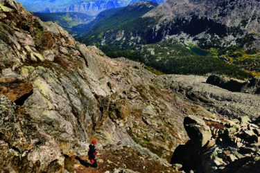
The Hike: Welcome to the Front Range, where accessible thirteeners can be as popular as fourteeners. And that’s just fine—especially since having some company can be comforting to novice peak-baggers. Plus, with expansive views north into Rocky Mountain National Park, west to Lake Granby, and south into the Indian Peaks, Arapaho’s beauty is worth sharing. From the trailhead, hikers will follow the well-established and popular Arapaho Pass Trail up a handful of gentle switchbacks. At mile 1.6, look for the ruins—a large tailings pile and a rusted boiler—of the former Fourth of July Mine. From here, turn right (north-northeast) onto the signed Arapaho Glacier Trail. The path zig-zags up the broad slope leading to the saddle between South Arapaho and a peak known colloquially as Old Baldy (look for a 13,038-foot elevation mark).
From the saddle, turn west and follow a gradually steepening ridgeline. You’ll want to stick close to the trail here as there are steep drops to the north into the Arapaho Glacier Cirque. The glacier is one of the most prominent snowfields viewable from downtown Boulder nearly year-round, but as a major source of the city’s water, it’s strictly off-limits. Hit the boulder-strewn summit and peer along the Class 3 ridgeline to North Arapaho Peak. (If you have the experience to navigate exposure and semi-technical climbing, you can extend your day by tacking on that peak.) A bonus to sharing the top-out: You’ll have someone to assist you with that all-important summit photo.
Fair Warning: In general, if you stick to the trail in Class 2 terrain, you’ll be safe from dangerous exposure and shouldn’t have to execute difficult mountaineering moves. But on narrow ridgelines, like you’ll experience on South Arapaho, you will want to be wary of approaching inclement weather. High winds or rain can increase the risk of a nasty slip.
Getting There: The most difficult part of an Arapaho Peak climb might be getting to the trailhead. For its proximity to the Front Range, the Fourth of July trailhead is notoriously challenging to access. From Nederland, at the western end of Boulder Canyon, take Eldorado Avenue west toward the Eldora Ski Area. Travel through the hamlet of Eldora, passing the Hessie trailhead, where the road becomes the 4th of July Road. From here, the driving gets progressively more difficult and rocky. While a high-clearance or four-wheel-drive vehicle may not be necessary (you’re guaranteed to see at least one Accord or Prius at the trailhead), it would certainly make the journey less fraught. The road ends at the trailhead 8.8 miles from the beginning of Eldorado Road.