The Local newsletter is your free, daily guide to life in Colorado. For locals, by locals.
Trailhead Elevation: 10,404 feet
Summit Elevation: 13,294 feet
Hiking Distance: 8.5 miles, round trip
Time: Half-day hike
Drive Time from Denver: 1 hour
Closest Town with Services: Idaho Springs
Where to Park: St. Mary’s Glacier trailhead, off Fall River Road
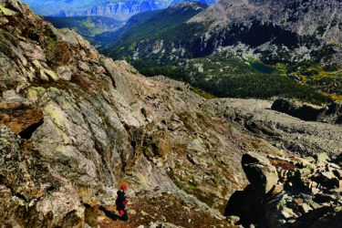
The Hike: A 13,294-foot summit accessed by a glacier—where are we, Washington? Not quite, but James Peak does give adventurous hikers a tiny dose of what the Pacific Northwest offers. From the trailhead, you’ll head up a well-traveled roadbed, which leads to St. Mary’s Lake after about a half-mile. Before the real hiking begins, take a breather and a few photos at this picturesque, treelined lake. Then, look toward the snowfield—aka St. Mary’s Glacier—just above the lake to the north. The glacier (or what’s left of what was once a much larger block of ice) hides in a gully leading up James Peak’s eastern shoulder. You’ll walk from the lake just a couple hundred yards north to the can’t-miss-it gulch and then decide to either hike up the snowfield or look for drier trails on the south side of the glacier. Either way, you’ll cross a four-wheel-drive road nearly a mile from the start of the gully and pick up the well-signed Continental Divide Trail going west toward James’ summit.
The well-trodden path travels along the top of a south-facing slope with spectacular views of Steuart, Reynolds, Caroline, Ohman, and Ice lakes as well as Loch Lomond, all of which are located in the basin between James Peak and 13,250-foot Mt. Bancroft (the summit looming southwest of the trail). Follow several switchbacks near the top and take the broad, gravely ridge to the pinnacle. James Peak sits at the southern end of the Indian Peaks. If you look north you’ll get a stunning vista of that range; if you steer your eyeballs south, you’ll see Mt. Bierstadt and Mt. Evans, both fourteeners. On clear days, you can even see Pikes Peak in the distance. You’ll return the way you came—having trekking poles would be helpful if you choose to head down the snowfield—but don’t skip the opportunity to dip your hike-weary feet in St. Mary’s Lake before trudging back to the car
Fair Warning: St. Mary’s Glacier doesn’t compare to the massive snowfields with yawning crevasses you’ll find on mountains in the Cascade Range in the Pacific Northwest or in Alaska, but it’s best to be prepared for an experience that’s more than just a walk in the snow. Bringing some kind of traction device for your boots (Microspikes work well) and trekking poles will help you keep your balance, especially on the descent. If you’re looking to improve your mountaineering skills, however, the glacier offers an excellent opportunity for some summertime practice with crampons and an ice axe. Quick tip: The glacier is also a popular place for summer skiers, so keep an eye on what’s happening above you.
Getting There: Take exit 238 off I-70 and follow Fall River Road up several switchbacks to the hamlet of Alice and the trailhead parking area nine miles from I-70. Look for signs and make sure you park in designated areas. Parking here requires paying $5 (cash/check only) to a self-service kiosk.