The Local newsletter is your free, daily guide to life in Colorado. For locals, by locals.
Trailhead Elevation: Trailhead parking lot, 10,380 feet; four-wheel-drive parking lot, 11,080 feet
Summit Elevation: 13,950 feet
Hiking Distance: Trailhead, 10.6 miles, round trip; four-wheel-drive lot, 7 miles, round trip
Time: Half-day hike
Drive Time From Denver: 1 hour and 40 minutes
Closest Town with Services: Breckenridge
Where To Park: If you have a two-wheel-drive vehicle, park at the Spruce Creek trailhead lot; if you have an all-wheel-drive or a four-wheel-drive vehicle, follow the rocky, dirt road for roughly two more miles until it terminates
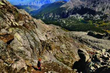
The Hike: There are multiple approaches to the majestic and ominous-looking Pacific Peak, which is just 50 feet short of being a fourteener. We opted for the Spruce Creek Trail approach, which winds through a breathtakingly beautiful gulch bordered by several 13,000-foot mountains.
If you can, take a four-wheel-drive vehicle past the Spruce Creek trailhead to reduce some lower-elevation hiking through unremarkable terrain on what is essentially a bumpy road. Once you start out on the real trail, you’ll wind through evergreens and pass some abandoned mining structures and equipment on what is an easy-to-follow path. However, there are multiple trails in the area; follow the signs to Continental Falls and Mohawk Lake. (Also don’t forget to bring a topo map and compass, and don’t be shy about asking fellow hikers for help with wayfinding.) Not long after passing the shallow Lower Mohawk Lake, you’ll take a short, steep uphill and be rewarded with the deep blue green waters of Upper Mohawk Lake. This is a good spot to take a snack break, analyze the weather, and savor the views.
From Upper Mohawk, enjoy the dirt path through the basin as you approach Pacific Peak, which rises like a shark’s tooth at the end of the gulch. You’ll pass a large unnamed lake and then take a left off the trail (there is another lake farther up the gulch; if you pass two unnamed lakes you’ve gone too far). Hikers will then climb up a rocky gully and follow a ridgeline to a plateau that’s home to Pacific Tarn, the highest named lake in the United States at 13,420 feet. From there, you continue past the tarn and trudge up the east ridge’s steep talus to the summit. From the apex, hikers can see 13,841-foot Atlantic Peak to the south and 13,852-foot Crystal Peak to the northeast.

Fair Warning: The hike to Upper Mohawk Lake and the basin below Pacific Peak will not be difficult for anyone in decent physical shape. It’s the route-finding inside the basin where things get tricky. With no signage, it’s easy to head too far up the gulch toward Pacific Peak and miss the left-hand turn between the lakes that takes hikers to the talus gully that serves as the approach to the east ridge. Have your map handy; study route notes in books or on 14ers.com; and be prepared to do some route-finding once you head up out of the drainage. This route may be rated Class 2, but it’s a difficult Class 2 after you start your summit push.
Getting There: Take I-70 west, then head south on CO 9 at Frisco. Pass through Breckenridge and continue south. Turn right on Spruce Creek Road and follow the signs to the Spruce Creek Trailhead.