


The Local newsletter is your free, daily guide to life in Colorado. For locals, by locals. Sign up today!
Fifty-four peaks. More than 140 routes. And hundreds of thousands of feet in elevation. With all of this lofty real estate in our backyard, it’s no surprise that clawing our way up the sides of 14,000-foot mountains has become a rite of passage for Colorado residents. But how does a rookie peak bagger choose which summit to reach for? We present the ultimate beginner’s guide to climbing Colorado’s famous fourteeners.
- Getting Started: All the Climbing Lingo and Equipment You’ll Need
- Mt. Bierstadt: A Close Encounter
- Grays & Torreys Peaks: Half the Battle
- The Decalibron Loop: The Four Pack
- Mt. Sherman: A Historical Twist
- Huron Peak: Scrambled Legs
- Now What? More Difficult Peaks and Skills You’ll Need
- The Doctor is In: Q&A About Climbing 14ers and Altitude Sickness
Glossary
Climbing lingo you’ll need to know—and use.

- The National Geodetic Survey Calculated New Elevations for Fourteeners. Who’s Up, Who’s Down?
- No, the “State of Colorado” Isn’t Buying the Stanley Hotel—Well, Not Really
- Everything You Need to Know About Denver-Area Farmers’ Markets in 2024
- A Denver Fan’s Guide to the 2024 NFL Draft
- What the New EXPLORE Act Will Mean for Coloradans
- An Ode to Frasca Food and Wine
- Hike We Like: Mt. Sanitas in Boulder
- Acute Mountain Sickness (AMS)
- Caused by low-oxygen environments (anything above about 5,000 feet in elevation), this usually minor medical condition is often characterized by headache, fatigue, nausea, and dizziness. AMS can become serious during extended stays at very high or extreme altitude (above 11,500 feet). Fluid can build up in the lungs (high altitude pulmonary edema, HAPE) or brain (high altitude cerebral edema, HACE), both of which require immediate descent to lower elevation.
- Class
- Routes on Colorado’s fourteeners are generally rated by class. Classes 1 and 2 are “hiking” routes and include easy to moderately difficult hiking on good to slightly less-well-maintained trails. Routes that are classified as 3, 4, or 5 are considered “climbing” routes, which can range from moderate scrambling (Class 3) and climbing steep and dangerous terrain (Class 4) to technical climbing that requires rope and belaying (Class 5).
- Cairn
- A noticeable pile of rocks placed by hikers to mark a trail, particularly when the trail is difficult to discern.
- Saddle
- A high pass between two or more adjacent peaks. SCREE Small, loose rocks that often make stable footing difficult.
- Summit
- As a noun, the topographically highest point of a mountain; as a verb, the action of reaching such a high point.
- Standard Route
- he most common—and often easiest—path of a particular climb; many fourteeners have multiple routes to their summits.
- Traverse
- As a noun, a section of a route that progresses in a horizontal direction; as a verb, the action of climbing in a horizontal direction.
Pack It In
The must-have equipment list.
- DAYHIKING PACK
- Nothing heavy or bulky
- STURDY SHOES
- Cross-trainers or hiking boots will do fine
- LAYERS
- Summertime climbs can be chilly in the morning and hot in the afternoon
- WATER
- A bottle or a bladder is required; bring enough for your dog
- FOOD
- Pack trail mix, jerky, or granola bars to replace spent calories
- WATCH
- It’s good to keep track of time—afternoon thunderstorms are a real threat
- SUN PROTECTION
- Many trails are exposed and, at 14,000 feet, the sun is piercing
- HEAD LAMP
- POCKET KNIFE
- CELL PHONE
- You may not always have reception but bring it anyway—it could be a lifesaver
- MAPS AND A COMPASS
- Most of the “easy” fourteeners do not require route-finding skills, but it’s always good to have these in your pack
- FIRST-AID KIT
- If nothing else, you may want Band-Aids for blisters
- MATCHES
- This fits into the it-can’t-hurt category

Mt. Bierstadt
- Trailhead Elevation
- 11,669 feet (West Slopes standard route)
- Summit Elevation
- 14,060 feet
- Hiking Distance
- 7 miles round-trip
- Time
- 2.5 to 3 hours up; 2 hours down
- Drive Time From Denver
- 1.5 hours
A Close Encounter
I’m not going to lie: Peering up at a tall mountain while simultaneously thinking about climbing it usually gives me vertigo. But from the parking lot, the summit of Mt. Bierstadt—one of the closest fourteeners to Denver—looks entirely attainable. I tell myself it’s probably just the way the sunlight is hitting the treeless mountainside on this early July morning, but the 38th highest peak in the Centennial State is less intimidating than I expected. Which is maybe why, at 7:25 a.m. on a Monday, there are 60 other people layering up, lacing their hiking boots, checking that they have at least 1.5 liters of water per person, applying sunscreen, and taking a last (vault) potty break before they begin the ascent.
The first mile of the standard West Slopes route supports my idea that this might actually be a doable climb: It’s a relatively flat walk, mostly on a dirt path that morphs into elevated boardwalks in some of the swamp- ier areas. My husband, our six-year-old boxer, and I cruise along, taking in views of nearby ponds and the Sawtooth ridge, which is intimidating and snakes all the way to Mt. Evans. Once the climb really begins, it doesn’t let up. This middle part of the ascent is the most lung-busting, but there are some long switchbacks and great spots to pull up a patch of grass and snack on some oxygen. As a novice peak bagger, I am initially worried that my pace will be too slow, but as we climb higher it’s apparent there’s no need to rush. Afternoon thunderstorms are a real menace any time after 12:30 p.m., but the sky is still impossibly clear at 10 a.m.
From the outset, the trail is easy to follow and is mostly free of scree and boulder fields until we reach the final crest, turn left, and find ourselves looking upon a wide ridge that purses to the rocky summit. Before we make for the top, we look northwest to see Torreys and Grays peaks, peer down the dizzying backside of Bierstadt to spot Frozen Lake, and watch for small mouselike animals called pikas among the rocks.
The push to the summit does not have a well-defined trail. The landscape is a jumble of large boulders that will tax your already tired legs. My husband has to lend me a hand in a few spots, but the last 300 feet aren’t a punishing cardio workout. We force ourselves to go all the way to the tippy top to make certain we actually hit 14,060 feet. The blown-open views make us happy we do. —LBK
Wake-Up Call
Bierstadt is close enough to Denver that you don’t have to camp near the trailhead to get an early enough start. We awoke at 5 a.m., left our Denver home at 5:55 a.m., and were hiking by 7:30 a.m. If you want to camp the night before, there are plenty of backcountry spots along Guanella Pass, or you can grab a spot at the nearby Burning Bear or Whiteside campgrounds ($16, two vehicles allowed).
Dog Is My Climbing Partner
Parts of the Mt. Bierstadt trail go through the Mt. Evans Wilderness Area, which requires dogs to be on leash. We took our four-legged friend, who managed the route better than we did. However, hikers need to be aware they are responsible for their animal’s safety on the mountain. In August 2012, Colorado resident Anthony Ortolani took his dog Missy on a hike along the Sawtooth ridge and abandoned the five-year-old German shepherd after bad weather rolled in and the animal’s paws were too cut up for her to descend. The dog languished on the mountain for eight days before volunteer rescue hikers found her and saved the dehydrated 112-pound shepherd. Ortolani pleaded guilty to a charge of animal cruelty in October and was sentenced to a year of unsupervised probation and 30 hours of community service. Bottom line: Treat your pooch like any other hiker.
Getting There
From Denver, drive west on U.S. 285 until you reach the town of Grant. In Grant, turn north on Guanella Pass Scenic Byway and drive about 13 miles to the top of Guanella Pass. You’ll see the parking lot for the trailhead on the right.

Grays & Torreys Peaks
- Trailhead Elevation
- 11,280 feet (Grays Trail standard route)
- Summit Elevation
- Grays, 14,270 feet; Torreys, 14,267 feet
- Hiking Distance
- 8.25 miles round-trip
- Time
- 4 hours up; 2 hours down
- Drive Time From Denver
- 1 hour and 15 minutes
Half The Battle
Coloradans have a bad habit of being a little too flip about climbing fourteeners—I mean, c’mon, these are huge mountains!—and that’s especially true with Grays and Torreys peaks. The mountains, which are a short drive from Denver, are wildly popular beginner fourteeners because their respective terrains are moderate and hikers can do both in a single day-trip. So…I try to be dismissive of the excursion as well. I know I will still have to schlep up two summits, but, as my friends remind me, the mountains are connected by a saddle, making it comparatively easy to hike up one and cross over to the other.
At least, that’s the refrain I repeat to myself as we drive west on I-70 to begin our early morning climb. It’s still chilly at 8 a.m. on a late-summer day when we layer up in Under Armour and sweatpants and strike out on Grays Trail, a dirt path that dissolves into gravel before larger rocks and boulders appear as we climb higher. Unlike many fourteeners, the treeless peaks of Grays and Torreys are visible from the outset. But as we ascend, the mountains don’t appear to be getting any closer. They are, I decide, mocking me. But I am undeterred. We continue upward, the sun warming our backs on the wide-open trail. We curve left, then right, and back again as the grass-lined route undulates through the postcard-worthy valley. At the trail junction about two miles in—where hikers can choose to tackle Grays first or Torreys—we stop to rest, snack, hydrate, and de-layer. The summits still look painfully far away, but I am feeling good—enjoying myself even. Most of our fellow peak baggers—we are joined by a few hundred other hikers, though the trail never feels too crowded—head left toward Grays, so we venture right, putting Torreys squarely in our sights. Using rocks as stepping stones, we follow cairns to the saddle, which lies about 500 feet from the summit of Torreys. It is here, after spotting a family of mountain goats precariously balanced just off the path, that I notice a distinct change. The mountaintop looms large, but I’m losing my drive. I’ve consumed more than a liter of water, yet I notice a light throbbing in my head. I suddenly feel a little weak, sluggish. I know immediately I’m suffering mild altitude sickness.
The symptoms aren’t subsiding after a five-minute break, but they’re not bad enough to force me to stop. Not when I’m so close. Slowly, we trudge the final feet and reach the summit. We are greeted by a few dozen others, beers in hand, who arrived there before us; many of them have already ascended Grays. I look south toward the sister peak. It doesn’t appear that far away—but my body simply won’t let me do it. Instead, I descend and watch one of my companions skirt the saddle to crack a beer of his own at 14,270 feet. In my case, the Rocky Mountains won half of the battle, but as much as I wish I had been able to summit Grays, I am proud to say I conquered Torreys. —Daliah Singer
A Full Itinerary
If you live in Denver, camping nearby the night before isn’t necessary to hike Grays and Torreys. But if you want to make the fourteeners part of a weekend excursion, plan a hike to nearby Chihuahua Lake, outside of Keystone, which you can see from both summits. You’ll want a four-wheel-drive vehicle to reach the trailhead.
Feel The Burn
Up the adventure quotient on your fourteener quest by approaching Torreys Peak via the more technical Kelso Ridge. You’ll follow Grays Trail until, at around 12,300 feet, instead of curving left you’ll turn right toward some old mining buildings. The exposed ridge is a Class 3 scramble over hunks of granite. Some people choose to bring a rope and harness, though it’s not required. Instead of the difficult descent, follow the traditional trail to conquer Grays or head all the way down.
Getting There
Take I-70 west to the Bakerville exit (221). Turn south onto Stevens Gulch Road/CR 321 and continue for about four miles—you’ll see signs for the Grays Peak trailhead—until you reach a parking area.

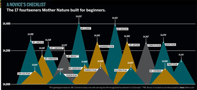
The Decalibron Loop
- Trailhead Elevation
- 12,000 feet (Combo standard route)
- Summit Elevation
- Mt. Democrat, 14,148 feet; Mt. Cameron, 14,238 feet; Mt. Lincoln, 14,286 feet; Mt. Bross, 14,172 feet
- Hiking Distance
- 7.25 miles round-trip
- Time
- 6 hours round-trip
- Drive Time From Denver
- 2 hours
The Four Pack
The DECALIBRON LOOP is a well-known mountaineering route that lies less than 15 miles outside of Fairplay. The undulating trail allows hikers to summit four 14,000-foot peaks in one day, which is not an uncommon feat. There are at least a dozen groupings of fourteeners that can be conquered in a day-trip.
Mt. Democrat
Although it’s the shortest and first mountain I summit, Mt. Democrat requires the day’s most strenuous climb. From the Kite Lake Trailhead, a mild start to the ascent unfolds before two long, steep traverses put me at the saddle between Mt. Democrat and Mt. Cameron. A giant rock garden to the south looks like it leads to the summit, which doesn’t appear to be all that far off. Except, when I arrive at the top, it’s not the top at all: What looks like the end of my climb is a false summit. It’s another 250 feet skyward to the west to reach the true apex, from which point I see much of the rest of my (up-and-down) day laid out before me.
Mt. Cameron
The drawback to conquering so many summits in a dayhike is the requisite backtracking. After snapping pics at the top of Democrat, I retrace my steps through the rock garden back down to the saddle between Mt. Democrat and Mt. Cameron. I pause here for a midmorning snack and ponder whether I’m really ready to hike farther: This is the best turnaround point before I’m committed to completing the entire loop. I decide I’m game. The haul to the zenith of Mt. Cameron is easily the most exhausting of the day—not because it’s any more difficult but because my legs are already weary from the 2,148-foot ascent of Democrat. To add insult to what feels like respiratory injury, Mt. Cameron doesn’t officially count as a fourteener. The flat summit of Mt. Cameron only rises 138 feet above the saddle to adjacent Mt. Lincoln. According to someone’s arbitrary and, I think, silly rules, Cameron’s high point would need to rise 300 feet above that saddle to claim the fourteener title on its own. I count it anyway.
Mt. Lincoln
The view from the eighth-highest peak in Colorado is worth the short but steep pebble-strewn climb. I’d probably perch here for hours if I could; however, space is at a premium on Mt. Lincoln. Any more than 15 people crowded atop the rocky summit makes even the most stable hiker leery of the sheer cliffs. There are a few folks climbing up behind me, but it’s the wind that sends me in search of lower terrain. And thankfully, it’s almost all downhill from the top of Lincoln. I relish the easygoing ridgeline hike before entering a series of switchbacks that leads me back to the trailhead—or, for those who’ve made special arrangements, to Mt. Bross.
Mt. Bross
This 14,172-footer is one of the 54 recognized fourteeners, but unless one has permission (a near impossibility) the climb is illegal; the privately owned peak requires permission from landowners to summit. The Colorado Fourteeners Initiative, a nonprofit that preserves the state’s fourteeners, is working with landowners to open the summit, but for now the organization recommends hikers respect those property rights. Hikers do often make the push up this final summit without approval, but it’s important to be aware of trespassing laws (specifically CRS 18-4-504) and their penalties, which can range from a $50 to $750 fine and include jail time. The trail down from Bross zigzags inside the cirque and is littered with steep declines and pea gravel. Hikers will want to de-layer as they descend and stop to dip their toes in the creek near the hike’s end. —Lindsey R. McKissick
Ticktock
Based on a moderate pace, the suggested Decalibron Loop start time is no later than 6:30 a.m. This is made easier by snagging one of the free camping spots just feet off Buckskin Street near the trailhead. Show up midafternoon on the day before your hike as the free sites often fill up in the late afternoon. Or take your chances with the five nonreservable paid sites at the Kite Lake Campground, which cost $15 per night ($12 for camping, $3 for parking).
Getting There
From Breckenridge, take Colorado Highway 9 about 16 miles south to Alma, Colorado. Take a right on CR 8/Buckskin Street and drive about six miles to the Kite Lake Trailhead. The closer you get to the trailhead, the dirt road turns from passable washboard to a treacherous four-wheel-drive path. Park and walk if you’re concerned about your vehicle’s clearance.
Permission Slip
Should permits be required to climb our famed peaks?
Coloradans like to think of the Rocky Mountains as pristine wilderness, but the truth is many of the state’s popular fourteeners—like Longs Peak, Mt. Bierstadt, Mt. Elbert—are experiencing overexposure. To combat the degradation and overcrowding, local wilderness officials have been discussing a permits system, which would decrease the number of people who climb Colorado’s high hills. One such proposal surfaced in 2010 for the South Colony Basin, a spot known for its access to three fourteeners. The U.S. Forest Service began kicking around a $10 day-use permit to pay for necessary maintenance. The proposal met with resistance but is still under consideration, according to the U.S. Forest Service’s Jim Bedwell.
Bedwell concedes there are problems with permitting, including the cost and staff necessary to manage the paperwork and the patchwork system of organizations that would need to issue said permits. Lloyd Athearn, executive director of the Colorado Fourteeners Initiative (CFI), shares those concerns (the nonprofit itself has no formal position on the issue), and adds limiting use doesn’t always mean limiting damage.
That’s why CFI and other similar organizations focus on building trails that can mitigate harm caused by thousands of footfalls. Athearn says a permits system could hurt his organization’s efforts: Hikers who have to pay to climb may be less willing to donate to organizations like his, and more important, money from permits doesn’t always necessarily go toward on-mountain maintenance—which means a permits system could be a detriment to the only solution anyone’s found for rescuing our state’s too-trampled fourteeners. —Dan England
Mt. Sherman
- Trailhead Elevation
- 12,000 feet (Southwest Ridge from Fourmile Creek standard route)
- Summit Elevation
- 14,036 feet
- Hiking Distance
- 5.25 miles, starting at the gate
- Time
- 2.5 hours up; 1 hour down
- Drive Time From Denver
- 2 to 2.5 hours
A Historical Twist
Taking a lowlander to altitude and then asking her to summit a tall mountain is almost never a great idea. In fact, it’s often a recipe for respiratory distress. But I’d gotten the day off from work to conquer what would be my ninth fourteener—and I needed a climbing buddy. So I texted my friend Emily, who happened to be visiting from the East Coast.
“Wanna do a fourteener with me on Friday?” Although Emily had lived in Colorado off and on for five years before moving to Boston, I knew she’d never done a fourteener. She texted me back with a quick, “Yes!” On the morning of the hike, we pack the car with provisions, agree if at any point Emily can’t handle the elevation we’ll turn around, and leave Denver around 8 a.m. We reach the trailhead at 10:30 a.m. I’d hoped to get there earlier to avoid afternoon storms, but sleeping in got the better of us. We luck out with a bluebird day.
The first half of the hike is gradual; an old rock-strewn road winds us up and around various mining ruins, including the Dauntless and Hilltop mines, where we stop to take a few snaps. The surrounding landscape is also photo-worthy, although maybe not beautiful in the traditional sense. The mountainside is rocky and barren, but the cobalt sky is a brilliant contrast to the ruddy orange hues of the Colorado clay and gray rock that dot the mountain. During our lunch break near the Hilltop Mine, we sit on a side trail with our feet outstretched, taking in the views of the valley and Fourmile Creek Road. I try not to let on that I am watching Emily closely, but at 12,800 feet in elevation, she seems to be handling the hike just fine.
We continue, and at the top of the saddle between Mt. Sheridan (a thirteener) and Mt. Sherman, the town of Leadville slides into view along with a breathtaking look at Turquoise Lake. With vistas like this, I am eager to reach the summit. We start up Mt. Sherman’s southwest ridge, at about 13,150 feet, when I realize we need to stop. I tell Emily to slow down—but not because she needs a breather. Instead, I’m the one in need of a short break. I huff and puff and dive into my trail mix for fuel. I look at Emily with amazement as she waits for me, even offering a gulp of her water. She—a flatlander!—is out-hiking me. As a longtime Coloradan, I feel a twinge of embarrassment.
But that feeling melts away as we reach the most difficult portion of the hike—a narrow edge laced with scree. We skirt over it, taking care not to dwell on the drop-off. Instead, we fixate on our destination, the oh-so-close summit, where we relish a deep breath and the knowledge that we made it to the top together. —Dana Pritts
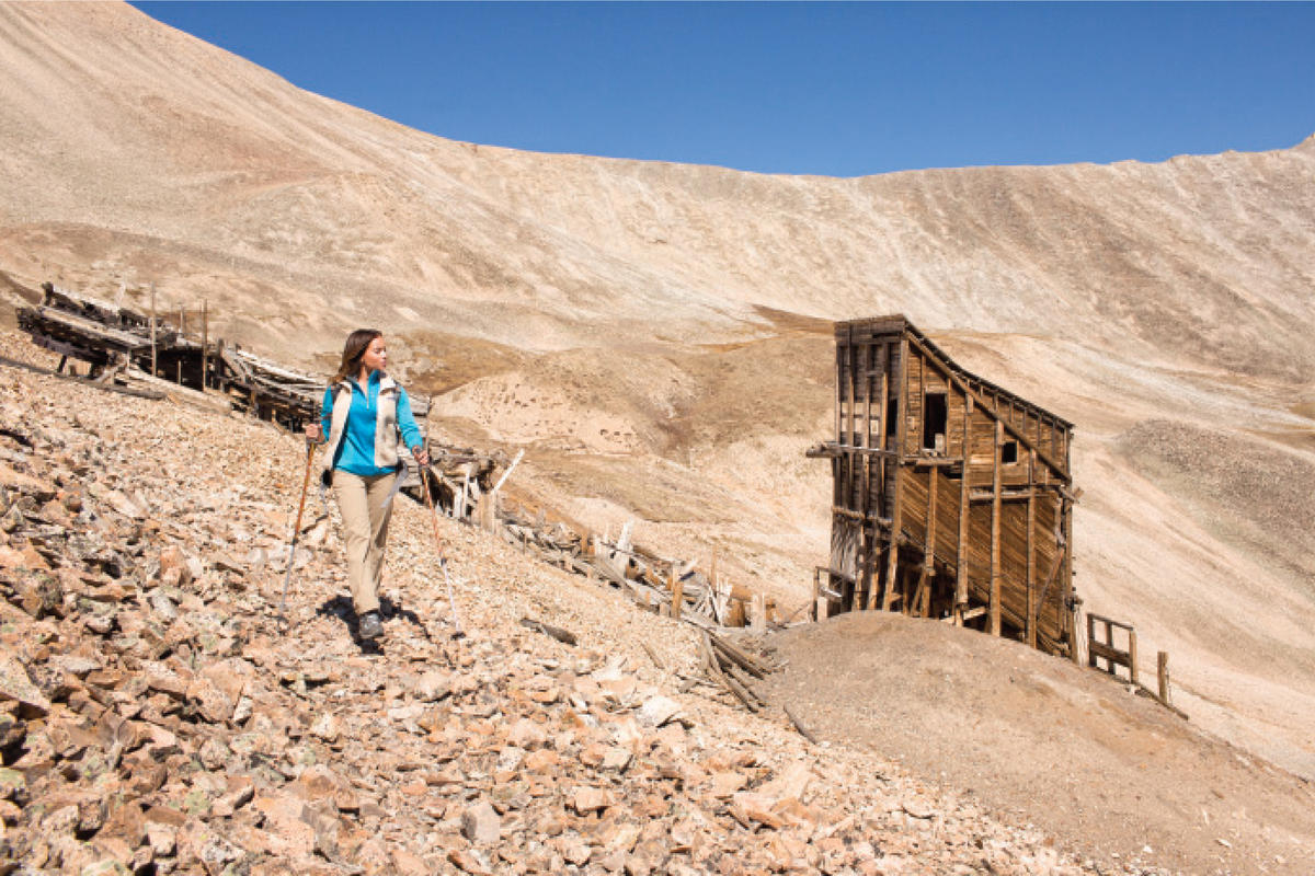
Look Into The Past
The mining town of Leavick sprang up in 1881 on the east side of Mt. Sheridan and in its heyday boasted a population of more than 200 hearty souls who lived their lives in search of gold, silver, and zinc. Mining ruins now pepper the entire area, including the hiking trails, and make for great side jaunts and photo opportunities. You’ll definitely lay eyes on the Dauntless Mine and the Hilltop Mine. Be careful, though: The ruins are fragile and unstable; do not enter or touch the structures.
Getting There
From Fairplay, drive about a mile south on U.S. 285, then turn right onto CR 18. You’ll drive along this road until you reach a closed gate at about 12,000 feet. This gate marks the trailhead. On busy summer weekends, you may not be able to park at the trailhead. Instead, park at a lower-elevation pull-off and hoof it to the gate.
The First Peak Bagger
Carl Blaurock pioneered a craze that lives on today.
Prospectors and American Indians hiked many of Colorado’s highest peaks way back in the 1800s, but it’s safe to say that no one had climbed all of the state’s fourteeners until 1923. That year, Denverites Carl Blaurock and Bill Ervin completed the list of 46 (revised surveys later raised the count to 54) by summiting Kit Carson Peak in the Sangre de Cristo Range. In the ’20s, there were no guidebooks, no trip reports on 14ers.com, not even roads to many trailheads. Blaurock, who climbed his first fourteener, Pikes Peak, at age 15, recalled that he and Ervin would ride the train from Denver to Creede and “walk over to Ouray and Telluride and climb the peaks in between.” For perspective: The shortest walking route between Creede and Telluride is at least 75 miles and traverses the state’s wildest terrain—and that’s before any detours they took to bag other peaks.

To put their feat into further context, lightweight, weatherproof Gore-Tex was but a dream for these hardy hikers. Blaurock wore Army surplus wool shirts, neatly buttoned at the collar, baggy Army britches with puttees, and a floppy wool hat. The climbers smeared a concoction of charcoal and petroleum jelly on their faces to serve as sunscreen. And when the wind howled, they stuck folded newspapers inside their shirts and trousers for extra protection.
Though today he would be labeled an “extreme” climber, Blaurock welcomed beginners on his hikes and never took himself too seriously. In fact, Blaurock was known for celebrating successful ascents by doing a headstand on the highest point of each mountain he climbed. He was also a charter member of the Colorado Mountain Club (which still operates today) and taught hundreds of others to climb and ski, including women, who joined his trips as often as men. David Lavender, who Blaurock taught in 1927 to glissade down sweeping snowfields, wielding an ice axe as a brake, wrote of his mentor’s “gentleness, patience, and ability to make others feel comfortable on an uncomfortable cliff.” —Dougald MacDonald

Huron Peak
- Trailhead Elevation
- 10,560 feet (North Ridge from Clear Creek standard route)
- Summit Elevation
- 14,003 feet
- Hiking Distance
- 6.75 miles round-trip (11 miles round-trip if you hike the four-wheel-drive road)
- Time
- 3.5 to 4 hours up; 1.5 hours down; add 4.25 (relatively flat) miles’ worth of time if you must hike the four-wheel-drive road
- Drive Time From Denver
- 3.5 hours
Scrambled Legs
Huron Peak can barely call itself a fourteener. It pushes past the mark with just three feet to spare—as if one little boulder at the top is jutting over the measuring stick. Reports describe this Sawatch Range beauty in the San Isabel National Forest as “scenic,” “enjoyable,” and “a great choice for my first fourteener.” Having scampered up plenty of peaks over the years, I figure I’m in for a mild, ho-hum ascent when we set out one Saturday in early September.
Not quite.
Admittedly, my friend and I get off to an easy start when we hitch a ride with two other hikers along the old jeep road between the lower and upper trailheads. The two-mile dirt stretch is usually passable only in all-terrain vehicles—definitely the way to go if you want to cut two nonscenic miles out of your hike each way.
By 8 a.m. we’re on the trail (the path forks in two directions at the trailhead; look for the wooden “Huron Trail” sign marking the left-hand standard route, also known as the North Ridge). Navigating switchback after switchback through the woods, we move steadily through the pine-scented air, and I try not to notice how hard I’m breathing each time we hit a steep pitch. Just shy of 12,000 feet we break timberline, and our heads-down push through the forest is rewarded with sprawling views of a trio of peaks aptly named the Three Apostles.
Shortly after, the trail dips into a grassy meadow basin surrounded by 360-degree views of the Collegiate Peaks Wilderness. Hefty boulders dot the well-maintained trail, making for convenient resting points to guzzle some water or scarf a granola bar. But when the path rises out of the basin and melts into a stone staircase along a ridge, every step provokes a new muscle spasm in my quads. Eventually, the marked route dissolves into one big rocky pitch upward—basically a Choose Your Own Adventure scramble—about a quarter-mile from the summit.
Red-faced, legs shaking, and lungs on fire, I crest the last cluster of boulders around 11:40 a.m. I want to collapse on the rock and nap on the summit all afternoon. Instead, we settle for 30 minutes, a sandwich, and panoramic views that render my start-and-stop slog (and my silly notion that any fourteener would ever be an easy stroll) a distant memory. —Julie Dugdale
Tip
If you don’t have a four-wheel-drive vehicle that can make it about two miles up a rutted dirt road to the upper lot and trailhead gate, you’ll need to park and walk starting from the lower lot at 10,260 feet.
Bring The Tent
Huron is a haul from Denver—too much for a day-trip. If you have a car that can handle it, there are some nice dispersed backcountry camping spots along the four-wheel-drive dirt road before the trailhead. Drive down midday on Saturday, set up your camp, cook a hearty meal around the campfire, and get a good night’s rest. Hit the trail right outside your tent in the morning. Or, leave Denver in the wee hours to arrive at Huron early, keep your camping stuff in the car, and set up your campsite after you finish your trek—a plan that’s much more conducive to kicking back with some celebratory drinks around the campfire.
Mix It Up
If you have an extra day, take the right fork at the trailhead for a 7.6-mile round-trip hike to Lake Ann, a serene alpine gem worthy of a trip by itself. Make sure to stay right when you get to the Apostle Basin junction after about 1.5 miles; going left will take you up the Southwest Slopes route to the summit of Huron (a trek about a mile longer than the standard trail that requires route-finding skills). After a couple of creek crossings, you’ll get to another fork at 3.7 miles; stay left this time to reach the lake.
Getting There
From U.S. 24 (15 miles north of Buena Vista, 19.3 miles south of Leadville), take CR 390 west for 11.7 miles to the ghost town of Winfield. Turn left to stay on CR/Forest Road 390 and continue 0.3 miles to the lower lot. If you have four-wheel-drive, continue up the jeep road for another two or so miles to the upper lot trail gate.
Climber’s Toolkit
If you’re ready for more difficult terrain, here are three talents you’ll need to hone. —DE
Scrambling
This skill requires the ability to move over challenging and exposed terrain without the use of ropes. Routes that require scrambling are rated Class 2 up to Class 4. Check out Colorado Scrambles (Colorado Mountain Club Press, 2005) by Dave Cooper for routes to learn on.
Route Finding
To climb more difficult mountains, you’ll need to be able to find the best way up a peak. Learn to recognize when a mountain feels more difficult or is taking longer than it should. That can mean you’re off the best route. And while there are no posted signs, cairns set out by previous hikers often mark the way. Being able to navigate using maps and a compass is also a good idea.
Focusing
It’s OK to be nervous about falling, but fear should focus you, not paralyze you. Learn to be confident on climbs with significant drop-offs and skinny pathways because those things are a part of more challenging fourteeners. You’ll gain that confidence with every climb, but going with a guide or a more experienced friend can help.
Think You’re Ready?
These fourteeners will show you what the harder ones are really like.
Mt. Sneffels
(14,150 feet) This peak in the San Juan Mountains offers a scree-filled gully that feels as if you’re hiking up marbles and a spooky exposed notch just before the summit.
Mt. Lindsey
(14,042 feet) From the Northwest Ridge Loop route, there are two ways to reach the top—and both are dicey. One is more exposed but solid, and the other veers from the cliffs but is full of loose scree.
Mt. Eolus
(14,083 feet) This peak, deep in the Needle Mountains, challenges your comfort with exposure. They don’t call it the “sidewalk in the sky” for nothing, but the route is solid and fun.
Coming Up Short
Our sub-14,000-footers deserve love, too.
Colorado’s fourteeners get all the attention, but many other peaks are just as fun to climb. Dan England, outdoor and entertainment editor for the Greeley Tribune, occasional mountain guide, and conqueror of all of Colorado’s fourteeners, suggests four shorter hills.
Flattop Mountain
(12,324 feet, Easy) Unlike many in its height category, this popular peak in Rocky Mountain National Park (RMNP) offers a trail all the way to the top. Take a left at the summit to hike over tundra and hit Hallett Peak (12,713 feet), about a half-mile jaunt away, for a stunning view of Longs Peak.
Mt. Audubon
(13,223 feet, Easy) The Indian Peaks Wilderness’ most well-traveled peak has a trail almost all the way to the summit, and yet its wild beauty and breathtaking views make it feel like a much more exciting adventure.
James Peak
(13,294 feet, Moderate) Many aspiring mountaineers—the kind who might one day like to summit more dangerous and exotic peaks—learn how to navigate snow and ice by trekking this peak’s St. Mary’s Glacier route.
Mt. Alice
(13,310 feet, Difficult) The long approach is the bane of any peak bagger’s existence, as the fun stuff often occurs near the summit. Mt. Alice’s approach is a really long 18 miles, but the journey truly is the reward. Alice’s trail winds through the Wild Basin segment of RMNP, an underrated beauty full of waterfalls, streams, and the famous Lion Lakes. Alice’s summit, if you can believe it, is boring in comparison.
The 411
Credible information from local sources.
- 13ERS.COM
- 14ERS.COM
- 100SUMMITS.COM
- Colorado Mountain Club, CMC.ORG
- Colorado Fourteeners Initiative, 14ERS.ORG
The Doctor Is In
Dr. Peter Hackett, the founder of Telluride’s Institute for Altitude Medicine and one of the world’s leading experts on high altitude–related illness, talks about reducing the risk of altitude sickness and who shouldn’t climb fourteeners. —LBK
Can Denverites get AMS while hiking a fourteener?
Yes, but it is usually mild: Headaches, heaviness in the legs, and shortness of breath are normal when going to 14,000 feet. Some folks will also get nauseated. Denverites will have about half the incidence of AMS compared to lowlanders.
What can peak baggers do to combat AMS?
Hike at a steady but moderate pace. Avoid dehydration by drinking enough to maintain clear urine. If you’re accustomed to caffeine intake, be sure to have your usual amount the day you’ll be climbing. And stay fit—although AMS is not directly related to fitness, being fit makes the hike more enjoyable and a touch of AMS easier to tolerate. Take ibuprofen with you on the hike, and either use it at the first sign of a headache or take it preventively. As long as the hike is a day-trip, and you will be returning to a lower altitude within hours, there is no danger of serious illness, so immediate descent is generally not necessary when AMS develops. That is, it is safe to push on to the summit with some symptoms.
What don’t most people understand about physical exertion at high altitudes?
That exercise capacity is markedly reduced, and that intensity of exercise needs to be reduced to avoid exhaustion. Also, the greater the exertion, the more likely they’ll experience symptoms of AMS.
Are there any pre-existing conditions that may make climbing a fourteener a bad idea?
Yes. Most doctors recommend not going over 11,000 to 12,000 feet during pregnancy, but this is not based on data, and it’s unlikely that a one-day exposure to high altitude would cause problems. Since we’re dealing with day-trips, most problems such as high blood pressure, diabetes, and atrial fibrillation are not a concern. But in terms of impacting performance, lung disease is at the top of the list. People with chronic obstructive pulmonary disease or cystic fibrosis will not generally do well. Neither will those with heart failure or pulmonary hypertension. However, it is not necessarily dangerous to go to altitude for these folks; it’s more that they won’t be comfortable and might have to turn around. The most important advice relates to exercise ability at low altitude: If a person can exercise with moderate to high intensity and/or duration at low altitude, they will generally do fine at high altitude.
Is there anything available over the counter that helps combat AMS?
People always want to know about herbs, supplements, and vitamins. The only such products ever shown to help with AMS are ginkgo biloba—about 100 mg twice a day for one to three days before climbing—and ibuprofen at 600 mg three times a day on the day of your hike.
—Model apparel generously provided by Patagonia Denver


