


The Local newsletter is your free, daily guide to life in Colorado. For locals, by locals. Sign up today!
Mesa Verde National Park is a world treasure, but it’s not the only thing worth seeing in the southwest corner of Colorado—or in any of the three other states that meet ours there. Here are 31 additional reasons to make the 420-mile drive.
Where the Wild Things Are

Just beyond the visitor center at Hovenweep National Monument, a collection of ancient dwellings perched on the edge of a canyon on the Utah-Colorado border, a trail sign reads, “If You Only Have 15 Minutes….” Standing in front of it, as the stone towers begin to glow in dawn’s light, one can’t help but wonder, Who comes all the way out here for 15 minutes?

Roughly 450 miles from Denver, Hovenweep sits in the middle of the Four Corners region—the beautiful, empty intersection of Colorado, Utah, Arizona, and New Mexico. The closest town of any size to Hovenweep is an hour away. This isn’t exactly a place you end up in by accident—and that’s precisely the point. Although many of us have heard of, or maybe even visited, Mesa Verde National Park and its famed cliff dwellings, the real treasures of the region come beyond the park’s boundaries—in the wrinkles and ravines of the 25-million-year-old Colorado Plateau.
This is the kind of place where every other car you pass has a dream catcher dangling from the rearview mirror. Where thunderstorms build so high and wide in the vast sky that the narrow strip of blacktop you’re driving disappears into a curtain of radiating sunbeams. Where map legends sometimes designate roads not as highways or county roads, but simply as “other.” And where rivers cut S-curves in rock once covered by ancient seas and where, thousands of years ago, Ancestral Puebloans carved homes into those same cliffs. It’s a place of movement, journey, and discovery, and while it takes some doing to get here—eight hours of driving from Denver, to be exact—the reward is an almost spiritual journey through a landscape where around every bend of road, knoll, or cliff band, history is plainly, spectacularly on display. There may well be no more obvious and accessible connection to Colorado’s past. Take your time to explore and absorb it. Or at least take more than 15 minutes.
You Only Have One Day…
(Must Do)

If you’re going to drive eight hours from Denver to Four Corners, we hope you’ll give yourself more than a single day to explore the majestic landscape. But for those of you who are simply passing through on your way to somewhere else (Moab is 145 miles farther; it’s nearly 500 miles to Vegas), here’s a one-day, cram-it-all-in-so-you-can-brag-to-your-friends itinerary.
9 a.m. Get a primer about the ancient tribes of Four Corners at the Anasazi Heritage Center in Dolores. The $4.8 million facility is one of the most engaging interpretive centers we’ve had the pleasure to enter. And it’s just $3. Things you must do, besides getting lost among the artifacts and interactive displays in the 40,000-square-foot visitor center: Grind corn with stone tools; weave on a Pueblo-style loom; and explore the nearly 1,000-year-old Escalante Pueblo on the hill above the museum while soaking up views of Ute Mountain.
11 a.m. Stop by Flat Belly Organics in Cortez on your way to Mesa Verde and pack your own picnic to enjoy in the park later.

Noon About 10 miles past the entrance for Mesa Verde National Park, you’ll see a sign for Park Point, the highest spot in Mesa Verde (8,572 feet). Since you’re limited on time—and still have about 10 miles to drive before you get to the largest caches of cliff dwellings—you’re going to be tempted to skip this. Don’t. The quarter-mile walk from Park Point’s parking lot to the fire tower and viewfinders presents a perspective you simply can’t get elsewhere: wide-open vistas of everything within 60 miles. You’ll see the San Juans to the north, Shiprock to the south, and—this month—a spectacular panorama of autumn painting itself across the hills in brilliant yellows, reds, and oranges. Unpack your picnic here or wait until you get to the Far View area five miles down the road. After lunch, drive the Mesa Top or Cliff Palace loops on Chapin Mesa. These six-mile tours have several pull-offs where you can see everything from early pit houses to cliff dwellings like Balcony House and Cliff Palace. For a more personal perspective on the dwellings, buy tickets for a ranger-led excursion (the $5 tours depart every half hour; Cliff Palace is currently closed to tours because of stabilization work but is still visible from the overlooks). While these guided hikes can be crowded with up to about 40 people and require climbing up ladders, they are the only way you’ll get up close to the ruins.

6 p.m. Four Corners Monument closes at 6:45, and it’s about an hour from Mesa Verde’s entrance, so leave the park by 5 to get there in time. This is the only place in the country where four states meet, which sounds a lot more exciting than it looks. Planted on top of the vast, arid Colorado Plateau and managed by the Navajo Nation, the monument itself isn’t nearly as interesting as the stalls of Navajo artisans selling artwork and jewelry. But since you’re already out this way, the photo op—feet in two states, hands in two others—is worth the $5 entrance fee.
Ute Mountain Tribal Park
(Side Trip)

For a more adventurous outing, opt for a full-day group or private tour of Ute Mountain Tribal Park (from $48). A Ute guide—nontribal visitors are not allowed into the park without a guide—leads guests to rock art displays and cliff dwellings that date back to the Basketmaker III era. Note: You must be able to hike three miles and climb a few ladders to access the dwellings. We suggest paying the additional $14 for provided transportation; you won’t want to diminish the experience by worrying about what the 80 miles of rutted gravel and dirt roads are doing to your suspension.
People Of The Past
A timeline of human history in the Mesa Verde region.
10,000ish years ago | PaleoIndian
Prehistoric humans hunt mammoths and other large mammals and gather in small groups.
6000 B.C.–500 B.C. | Archaic
As the climate warms, killing off big game, the hunter-gatherer population increases and their nomadic wanderings become more patterned; they move with the seasons, eating more fruits and berries and smaller animals.

500 B.C.–500 | Basketmaker II
Humans begin to cultivate crops, mostly maize, and remain in locations longer, building and living in more permanent structures, often dug into the ground, called “pit houses.”
500–750 | Basketmaker III
The Four Corners region sees a population boom as hunters transition from spears to bows and arrows and farmers cultivate additional crops. Single farms develop into communities with “great kivas”—large, public buildings for ceremonial purposes.
750–900 | Pueblo I
The villages grow larger, and more structures are built above ground than in previous ages. Near the end of this era, many residents migrate south to New Mexico, perhaps because of a worsening drought.
900–1150 | Pueblo II
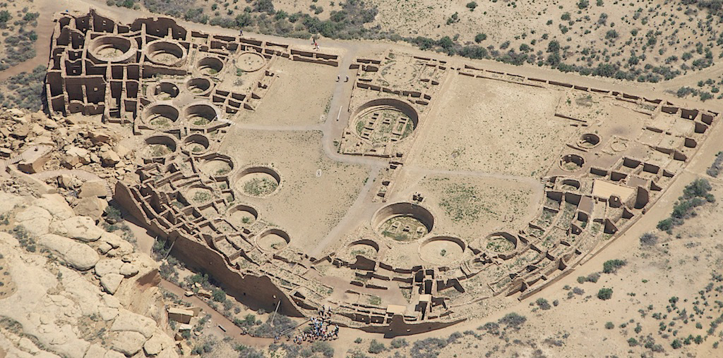
As the drought eases, people return to the Mesa Verde region. This is the first time the “great houses” typically associated with Chaco Canyon—large multiroom, multistory stone buildings—appear in the area.
1150–1300 | Pueblo III
Over the course of a century, residents move away from farms and into massive villages, often built at canyon heads or in rock alcoves. The population soars to roughly 20,000 before dropping off sharply around the year 1285; archaeologists aren’t entirely sure why.
1300–1700 | Post-Pueblo
Following the migration of the Ancestral Puebloans to New Mexico and Arizona, hunter-gatherer tribes from the west (the Utes) and the north (the Navajo) arrive. By the 1700s, the Spanish, who settled New Mexico, have begun exploring the area.
1700–2017 | Historic & Present
The United States claims control of Mesa Verde in 1848. After decades of war and the forced removal of native populations from their lands, President Theodore Roosevelt established Mesa Verde National Park in 1906.
The Most Underrated Adventures: Canyons of the Ancients
(Must Do)

In April, when President Donald Trump ordered Secretary of the Interior Ryan Zinke to review—and potentially dismantle—all national monuments established after 1996 that are larger than 100,000 acres, a single monument in Colorado landed on the list of 27: Canyons of the Ancients. Established in 2000, this 176,000-acre monument along the Utah border holds the largest concentration of archeological sites in the country. In some places, they can be as dense as 100 per square mile. What’s more, unlike the structures at Mesa Verde, which you can only enjoy from afar or amongst a crowd, Canyons of the Ancients is open to backcountry exploration. All you need is camping gear, water, and an adventurous streak, and you can discover 800-year-old pueblos, rock art, and pottery shards from ancient peoples all on your own (but please don’t disturb any artifacts or structures). For the intrepid who only have a day, there’s a 6.5-mile hike (one way) through Sand Canyon. From the southern entrance in McElmo Canyon, this trek takes you along canyon edges and through exquisite rock formations, passing cliff dwellings along the way. The highlight comes after a 4.5-mile climb: the Sand Canyon Pueblo. Built about the same time as Mesa Verde’s Cliff Palace—and three times its size—the pueblo’s walls have collapsed, but you are still free to (carefully) roam around the 450-room site. If boy-scouting your way through cacti and canyons doesn’t appeal, consider a visit to Lowry Pueblo, an easy-to-drive-to dwelling on the north end of the monument that’s been artfully excavated. Whatever adventure you choose, it’s now assured to be around for a while. In July, Zinke officially took Canyons of the Ancients off the endangered list.
Keep in Mind:
- Sand Canyon gets about 20,000 visitors per year. Mesa Verde? More than 600,000.
- Temps can reach 90 even in September. Bring plenty of water.
A Tale of Three Cities
Cortez, Dolores, and Mancos all sit within 30 minutes of Mesa Verde, and they’ve each got a unique vibe. Find out which one fits best with yours.
Cortez
Population 8,600

Go Here If… You crave cultural attractions and culinary options
Highlights: Equidistant to Mesa Verde and Canyons of the Ancients, Cortez boasts the Crow Canyon Archaeological Center, a “living” research center where visitors can assist with digs. Downtown, a cultural center/gallery housed in a beautiful 1909 mercantile building showcases local artisans, writers, musicians, and dancers (watch Native American dancers Monday through Saturday for free at 7 p.m.). And the food options here are more diverse than anywhere else within about 50 miles.
Drawbacks: In-town lodging options are limited to the standard budget hotel chains and roadside motels. Fortunately, the stunning Canyon of the Ancients Guest Ranch (see “Side Trip: McElmo Canyon” below) is located just outside of town.
Dolores
Population 950

Go Here If… You’re all about the water
Highlights: Nearby McPhee Reservoir is the second largest lake in the state (behind Blue Mesa Reservoir near Gunnison) and offers boaters, paddlers, and fishermen about 350,000 acre-feet of liquid adventure. Plus, the Lower Dolores tailwater is considered prime Colorado fishing territory, especially in the fall when the area’s brown trout—which average between 12 and 18 inches—are spawning. Bonus: This time of year, the foliage near the lake and above town makes for a breathtaking setting.
Drawbacks: Dolores doesn’t have much of a dining scene, so you’re probably going to want to eat most of your meals in Cortez. But it does have its own brewery (of course): Dolores River Brewery. And for a bit of midcentury nostalgia, stop by the Depot for a burger and shake.
Mancos
Population 1,400

Go Here If… You love art and history
Highlights: Mancos’ main commercial district is only a couple of blocks, but it’s packed with galleries and funky boutiques. Raven House Gallery and the Artisans of Mancos showcase more traditional pottery, paintings, photography, sculptures, and jewelry, while Beehive—a spa and boutique—leans toward a modern aesthetic. The self-guided historic walking tour of town will take you past all of them.
Drawbacks: As the easternmost town relatively close to Mesa Verde (Durango is another 30 miles east), Mancos can feel a little forgotten. That’s great if you’re seeking solitude, but not if you’re looking for supper on a Sunday night, when only a few places are open.
McElmo Canyon
(Side Trip)

Tucked between the southern border of Canyons of the Ancients and the northern edge of the Ute Mountain Reservation, a thin finger of land along McElmo Creek holds some of the region’s most spectacular—and little known—modern treasures. Exhibit A: Canyon of the Ancients Guest Ranch. This working ranch is the premier lodging option in the region, with six unique cabins and houses. Whether you stay in the 1880s-era Elden Stone House or the luxurious Mokee House—a modern structure modeled after ancient cliff dwellings and complete with its own lookout tower and a sky-lit stone shower you’ll never want to leave—you’ll find fresh, free-range eggs in your fridge and unrivaled hospitality from owners Garry and Ming Adams. If you can tear yourself away from the ranch for a day, tour the canyon’s two outstanding wineries—Guy Drew and Sutcliffe—just a few miles away. And while you’re at it, sign up for a trail ride through Sand Canyon with Canyon Trails Ranch and let a 14-hand quarter horse do the work.
How’d That Get There?
Some of the Four Corners region’s most notable rock formations.

Shiprock, New Mexico
This 1,500-foot landmark, which is visible from as far as 30 miles away, is actually the neck of an ancient volcano. Made up of minette, a type of igneous rock (rock created from magma), Shiprock likely formed below the Earth’s surface about 27 million years ago, when the San Juan region roiled with volcanic activity. Millions of years of erosion wore down all but the hardest rock, eventually exposing the neck of the volcano. The landmark, which sits upon Navajo Nation land, gets its English name from its resemblance to a 19th-century clipper ship. But the Navajo—for whom the rock is sacred—call it Tsé bít a’í, or “winged rock,” because the volcanic structures span out on either side like wings. Visitors are allowed to hike near Shiprock, but climbing is prohibited.

Mexican Hat Rock, Utah
Perched above the San Juan River on the edge of Bears Ears National Monument (one of the 27 monuments under review by the Trump administration; see “The Most Underrated Adventure” above), Mexican Hat Rock is a roughly 300-million-year-old sandstone formation that looks like a sombrero. (Yes, it’s not the most culturally sensitive name, but cultural sensitivity wasn’t top of mind in 1908 when E.L. Goodridge established a town of the same name after discovering oil there.) It was formed when sediment deposits built up on the edge of a coastal plain during the late Paleozoic era. That’s right—300 million years ago, Colorado and Utah hosted inland seas. Erosion shaped the sandstone into the formation we see today: a 60-foot-diameter disc stacked on top of a much smaller base.

Bisti Badlands, New Mexico
There are no developed trails and very little vegetation in these remote badlands, but it was once a lush rain forest. About 65 million years ago, Bisti Badlands (also called Bisti Wilderness and De-Na-Zin Wilderness) was a river delta that bordered what is known as the Western Great Interior Seaway, which divided North America. About 25 million years ago, tectonic plates shifted, uplifting the Colorado Plateau and exposing the sediment. Wind and water ate away at the layers, chewing into the softer rock faster than the harder part on top, creating impossibly balanced formations. The result: an otherworldly landscape of sandstone hoodoos that seems more suited for the moon than northwestern New Mexico.
Don’t Call Us Anasazi
(Local Knowledge)
Although you will certainly hear the ancient tribes that inhabited the Four Corners region referred to as “Anasazi” (a Navajo word that translates to “ancient ones” or “ancient enemies”), the preferred term is Ancestral Puebloans. We’ve collected a few other Trivial Pursuit–style tidbits you might find helpful when visiting.
Geography
Question: Four Corners’ north-south thoroughfare U.S. 491 was once called Highway 666, or the Devil’s Highway. Parts of it also fall along the path of the Long Walk, which was forced upon which Native American tribe?
Answer: The Navajo. In the winter of 1864, the U.S. government “relocated” more than 8,500 Navajo, forcing them to walk over 300 miles—from northeastern Arizona into New Mexico—in eight weeks. More than 200 people died during the Long Walk of the Navajo.
Entertainment
Question: What Four Corners(ish) town was memorialized in an Eagles song?
Answer: Winslow, Arizona, which sits outside of the Hopi Reservation, just off of Interstate 40. (Well, I’m a-standin’ on a corner in Winslow, Arizona // Such a fine sight to see // It’s a girl, my Lord, in a flatbed Ford // Slowin’ down to take a look at me.)
History
Multiple choice: Vietnam War Medal of Honor recipient Kenneth Worley, a Marine who jumped on a grenade to save his comrades in 1968, was born in what Four Corners town?
A) Cortez
B) Farmington, New Mexico
C) Teec Nos Pos, Arizona
D) Bluff, Utah
Answer: B. You can find a plaque dedicated to Worley in the All Veterans Memorial Park along the Animas River.
Science & Nature
Question: Evidence from which geologic era is visible in the canyon walls above the San Juan River near Bluff, Utah?
Answer: Mesozoic (252 million to 66 million years ago). This era contained the Jurassic period, when dinosaurs were wandering around.
Sports & Leisure
Fill in the blank: Sold roadside and at Navajo festivals in late summer and early fall, this tamalelike food is also known as ____ bread.
Answer: Kneel down bread. Kneel down bread is made with corn kernels from young stalks that have been shaved off, ground down, and then mixed with water, salt, and occasionally lard and wrapped inside corn husks. The husks are then cooked in a fire—typically in a covered pit in the ground.
Art & Literature
Multiple choice: Which of the following is the title of a book by Four Corners author Tony Hillerman?
A) Skinwalkers
B) A Thief of Time
C) The Sinister Pig
D) All of the above
Answer: D. All were part of Hillerman’s award-winning fictional crime series, which followed Navajo Tribal Police Officers Joe Leaphorn and Jim Chee. Hillerman died in 2008, but in 2013, his daughter, Anne, published the first of three new books featuring her father’s characters.
Canyon De Chelly
(Side Trip)

Arid and empty, the northeastern corner of Arizona contains the longest continuously inhabited area in North America: Canyon de Chelly National Monument. Five thousand years ago, Ancestral Puebloans lived here, followed by the Hopi and then the Navajo, who today manage the area in concert with the National Park Service. (Although Canyon de Chelly is a national monument, it falls entirely within the Navajo Nation; in fact, 40 Navajo families still live and farm within the park.) Nontribal visitors can peer into the 1,000-foot-deep canyon and its verdant valley-floor farmland by driving along the north and south rims (each 15 miles long) or by camping at Cottonwood Campground near the Thunderbird Lodge and hiking the 1.25-mile trail into the canyon. The best way to explore Canyon de Chelly’s beauty, though, is to sign up for a Jeep tour with a Navajo guide service such as Canyon De Chelly Tours or Canyon de Chelly Beauty Way Jeep Tours.
Ride the River
(Must Do)
For an intimate tour of human and geologic history, take a guided rafting trip down the San Juan River.

The area around Bluff, Utah, was once at the center of Ancestral Puebloan life; today, it’s at the center of adventures through Utah’s canyon lands. Monument Valley, Natural Bridges National Monument, and Canyonlands National Park are all accessible from this pioneer town, which was founded by Mormons in 1880 (you can still explore remnants of their original settlement at the Bluff Fort Historic Site in town). But the best way to marvel at the region’s geologic and human history is with a trip down the San Juan River. Four Corners Adventures & Wild Rivers Expeditions runs half-day to 10-day tours that include food and lodging (i.e., camping, but you don’t have to do any setup, cooking, or cleanup). If you have the time, do the full canyon tour (seven or 10 days), which takes you from Sand Island, just outside of Bluff, through Goosenecks State Park—where the San Juan folds back on itself so many times it almost touches in places—and all the way to Cedar Mesa’s slick sandstone walls. Most days, you’ll have an opportunity to hike to points of interest such as the Chinle Wash’s petroglyphs and cliff dwellings or Comb Ridge, an 80-mile-long wrinkle in the earth that was formed about 60 million years ago (around the same time the Rocky Mountains were born). Those who are pressed for time should still take the one-day float from Sand Island to Mexican Hat. Along the way, you’ll stop and view ancient rock art, get close to cliff dwellings like Snake House, and spot bighorn sheep as the river’s gentle curves tighten through a 1,300-foot-deep sandstone canyon. If you’re lucky enough to have Navajo tribal member Marcus Buck as your guide, you’ll get an especially insightful explanation of the landscape and its significance in Navajo traditions.
Road Food
Four Corners is rich in history—but culinary pursuits? Well, not so much. These spots buck the trend, though. Plan your eating itinerary accordingly.

Mancos
Fahrenheit Coffee Roasters: Fahrenheit has been serving Mancos well-balanced brews for 11 years. If you’re feeling peckish, Fahrenheit’s oversize homemade pastries—giant, gooey, delicious cranberry cinnamon rolls, anyone?—will tame your hunger.
Absolute Bakery & Cafe: It can be difficult to snag a spot in this tiny breakfast and lunch spot, but trust us: It’s worth waiting for sandwiches served on fresh bread, soups created from scratch, and (of course) decadent desserts (strudels and cookies of every imaginable variety). And since nothing on the menu costs more than $12, you’ll be able to splurge on a bunch of macaroons for the road.
Olio: Befitting its name (an “olio” is a miscellaneous collection of things), Olio is part restaurant, part wine bar, and part art gallery. Experience all three Tuesday through Saturday, starting at 5 p.m. Olio’s menu roams the globe with everything from grilled haloumi to lamb brisket to good ol’ dry-aged wagyu strip steak.
Cortez
Loungin’ Lizard: A lively locals’ favorite that’s as much bar as restaurant, the Loungin’ Lizard’s menu is packed with green-chile heat: Eat them chopped on a pulled-pork pizza or in green chile sauce over eggs, tasso ham, and an English muffin (the Southwest Benedict).
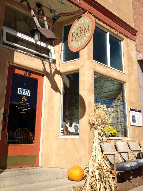
The Farm Bistro & Lounge: This eight-year-old restaurant is only open for lunch and dinner Monday through Friday, but its made-from-scratch-with-mostly-local-ingredients burgers (beef, bean, chicken, and yak), pizzas, and salads are worth extending your weekend.
Bluff, Utah
Duke’s: Attached to the Desert Rose Inn—whose cabins and lodge rooms, perched on the edge of the San Juan River, make it a convenient and beautiful home base—Duke’s boasts a New American dinner menu that provides plenty of (delicious) caloric prep for the next day’s adventure. (Note: Duke’s is a dry restaurant.)

Comb Ridge Eat and Drink: The menu at this coffeeshop and bistro is small but mighty. Order the cheeseburger and prepare for a mouth-stretching masterpiece made with Canyon of the Ancients Guest Ranch grass-fed beef and American cheese. Come back in the morning for one of the best cups of coffee to be had in the Four Corners region.
Farmington, New Mexico
AshKii’s Navajo Grill: This modest order-at-the-counter spot’s Navajo taco (beans, cheese, lettuce, tomatoes, and a roasted poblano pepper served on fry bread) is big enough to feed two—especially if you also order a side of blue mush. The traditional Navajo dish, akin to grits, is made from ground blue corn.
Three Rivers Eatery and Brewhouse: Founded 20 years ago, Three Rivers’ collection of restaurants and bars now takes up almost an entire block of East Main Street. The pub fare makes for a solid lunch, but the real treats are the stories staff will share—like the time former President Bill Clinton stopped in and Three Rivers had to contact the White House to collect on his bill.
Crack the Code
Understanding some of the emblems of the Four Corners area.
Kokopelli: Ancient depictions of this flute player can be seen throughout the Southwest—and on coffee mugs, T-shirts, and jewelry in just about every gift store in the Four Corners region. Although different Native American tribes have varying legends for Kokopelli, they largely center on fertility, both the human and agricultural kind.
Spiral: The spiral is found in many ancient cultures. The instances you’ll spot in Four Corners are likely part of the Hopi’s creation story. Some Hopi believe we’re living in the fourth of seven worlds. While different versions exist, one popular explanation is that the Hopi, who are descendants of the Ancestral Puebloans, arrived in our current world via an opening, or “sipapu,” in the Grand Canyon. The spiral could represent the sipapu.
Whirling Logs: This emblem showed up long before the Nazis co-opted it for their horrifying purposes. It can mean different things, but for some Navajo, it stands for “whirling logs.” The symbol, which can be found in Navajo sand paintings and textiles across several centuries, is believed by some to represent healing.
Choose Your Own Adventure
(Must Do)
Adrenaline and endorphins await in Farmington, New Mexico.

Mountain Bike at Hood Mesa
Every October, Farmington hosts one of the oldest mountain biking races in the country: the Road Apple Rally, where racers take on Glade Run Recreation Area’s slickrock and boulders. (Just keep an eye out for Jeeps and other rock crawlers while you ride.) You can sample the rest of the area’s singletrack on your own anytime. The Hood Mesa, Piñon Mesa, and Kinsey’s Ridge trails just north of town are popular options that hold miles of varied riding for every ability level.

Paddle the Animas River’s White-Water Park
Farmington sits at the confluence of the Animas and San Juan rivers, and the town made the most of that by installing a white-water park along the Animas on the south side of town in 1999. Paddlers won’t face anything more hardcore than Class II rapids through this section, but two surfable features present plenty of fun for developing paddlers. Adventurers with more terrestrial tendencies will enjoy the eight miles of trail that parallel the river, passing the white-water park as well as an impressive commemoration of veterans of all wars—going back to the War of 1812!—at the All Veterans Memorial Plaza.

Stare Down a Polar Bear
Set on a 12,000-acre working farm and wildlife refuge, the Bolack Museum of Fish and Wildlife houses more than 2,500 taxidermic animals, often displayed in artistic re-creations of their natural environments. Most of the animals—from giraffes to polar bears to big African cats—were collected by Tom Bolack, a hunter and former New Mexico governor. A conservationist at heart, Bolack targeted specimens that were often older animals nearing their ends anyway; he established the museum as a way of highlighting natural beauty so that others might be inspired to protect it. His kin continues his work today by maintaining a wildlife refuge on the family farm that is home to more than 15,000 year-round avian residents.
Bisti Badlands
(Side Trip)

About an hour south of Farmington, the hoodoo-dotted Bisti Badlands presents a hiking experience like few others. There are no trails through this 60-square-mile moonscape, which is decorated with impossibly shaped sandstone, beautifully carved ravines, and very little vegetation, so you can explore the surreal formations any way you wish. (Carry a map and a compass, plenty of water, and emergency gear; don’t count on cell service.) It’s best to visit in the morning before it becomes unbearably hot, and avoid this area if it’s rained hard recently, as the dirt roads can become slippery—plus, you’re likely to lose a hiking boot in shoe-sucking muck. Camping is allowed on this Bureau of Land Management property, but we recommend spending the money (starting at $310 per night) for a night of luxe cave dwelling at Kokopelli’s Cave just north of Farmington. Built into a cliff above the La Plata River valley, Kokopelli’s Cave affords visitors one-of-a-kind views of the sun setting on the basin 300 feet below.
Insta Envy
Between the incredible rock formations, wide-open skies, and ideal light, Four Corners is a photographer’s dream. In fact, it’s a favorite site for photography workshops. (Four Corners Adventures & Wild River Expeditions is running a few this month, as is esteemed Southwest photog Geraint Smith.) But if all you’re armed with is your smartphone, we’ve got you covered. Here are a few tips for capturing some of the region’s quintessential shots.

Cliff Palace at Mesa Verde
This is the iconic Mesa Verde shot. The secret to photographing Cliff Palace, the largest of the park’s cliff dwellings, is to shoot it when light isn’t hitting the structure directly (it washes out the sandstone). At west-facing Cliff Palace, that’s typically late afternoon. You’ll have to put plans for an up-close shot on hold since the ranger tours are closed this year while the park does some stabilization work, but the Cliff Palace and Sun Temple overlooks offer prime locations for panoramas.
Hovenweep National Monument
Planted on the Utah-Colorado border, Hovenweep once held upward of 2,000 people. Today, the remnants of stone towers perched on the edge of a 80-foot canyon make for striking photos—especially since the two-mile trail along and through the canyon takes you up next to some of the ruins. (Hovenweep was actually named by 19th-century photographer William Henry Jackson; it’s a Ute word that means “deserted valley.”) You’ll get great light near sunrise or sunset, but we prefer sunrise, when you’re more likely to capture the canyon’s wildlife, like coyotes and desert cottontails.
San Juan River Rock Art
One of the best-known rock art panels in the Southwest can be found just outside Bluff, Utah, along the banks of the San Juan River. The Butler Wash Panel, also called the Big Kachina Panel, includes petroglyphs that are up to 2,000 years old. Bright light will obscure some of the art’s details, so you’ll want to photograph in low-light conditions (early morning or evening) and avoid using a flash.
Know Before You Go

Cell service in many parts of Four Corners is spotty, so plan accordingly.
The dirt roads in this region can be as slippery as snow after a hard rain. Be cautious when driving in wet conditions.
You’ll only be able to go as fast as the car in front of you in Mesa Verde, so leave yourself about an hour to drive the 20 or so miles from the entrance to the cliff dwellings on the other side of the park.
The ranger-led hikes in Mesa Verde sell out quickly, but you can purchase tickets up to two days in advance.
Bring cash for souvenirs from the artisans at Four Corners Monument (they range from about $10 to $300). Not all artisans accept cards and checks, and the closest ATM is five miles away.
Parking at the southern entrance to Canyons of the Ancients’ Sand Canyon Trail is extremely limited; get there early.
The Navajo Nation Fair, the country’s largest annual celebration of Navajo culture, takes place in Window Rock, Arizona, from September 4 to 10. The event can affect lodging availability, travel times, and whether local businesses are open or closed.
The Navajo tribe owns the southern shore of the San Juan River. If you’re planning to camp there, you need to get a permit through the Navajo Nation.
A pretty—but poisonous—plant called datura grows throughout the Four Corners region. Ingesting just one leaf can be fatal, so don’t go snacking on nature’s bounty.


