


The Local newsletter is your free, daily guide to life in Colorado. For locals, by locals.
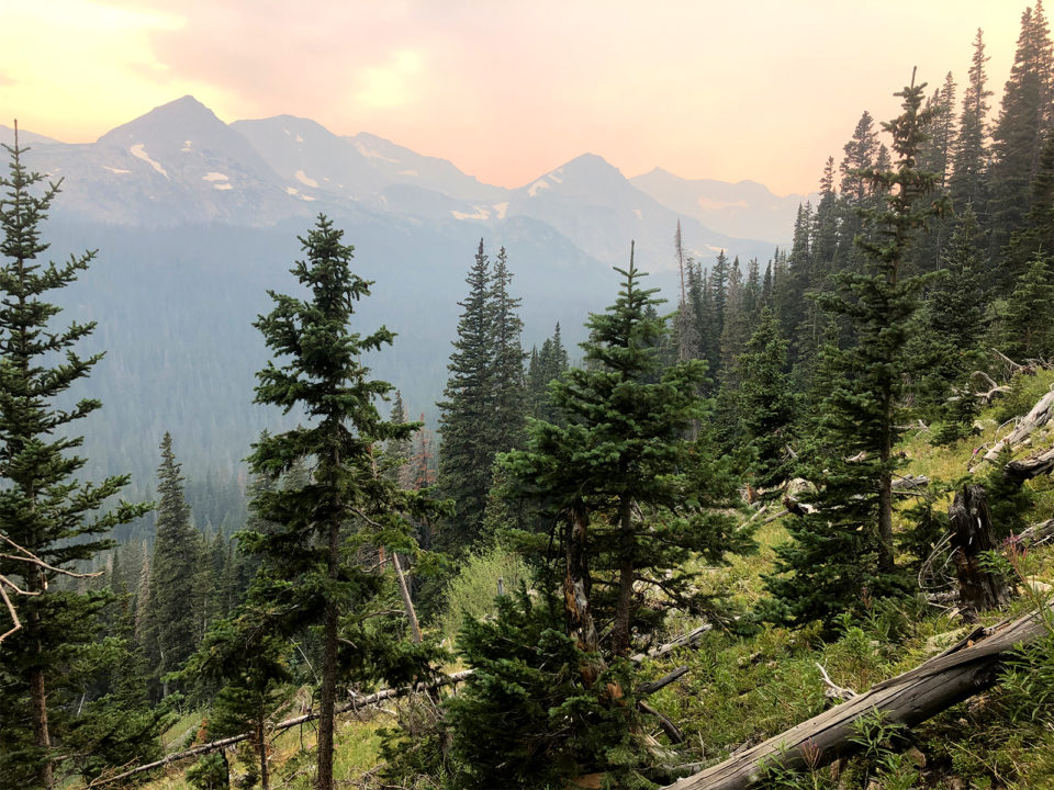
It’s 7 a.m., and I’m not sure where Maggie is. But I’m not concerned. The sun has crested the granite amphitheater beyond our campsite, unveiling a turquoise pool that reflects a coronet of chalky spires on its surface. There is no wind—a rare treat at 11,000 feet—and no sound either. Here, even whispers would mar the beauty.
I zip on a puffy jacket to cut the morning chill and pick my way down to our makeshift kitchen, hidden in a grove of firs, where Jenna already has a French press steeping and is watching a flapjack bubble on a teeny fry pan. We have been backpacking partners for years.

I slip past her to the rocky outlet, where water from Diamond Lake slides over ancient stones before it spills down to the North Fork Middle Boulder Creek, and then all the way back to Boulder, where we live. I spy Maggie perched on a log, staring at the rock cathedral. The Indian Peaks’ morning service is in session.
Of all the felicities we Front Rangers can brag about—craft beer, blower powder, Cale Makar’s stick handling—our backyard range is perhaps the most impressive. Just beyond the foothills we call home, glaciers frost 13,000-foot peaks, meadows teem with late-summer wildflowers, and black bears, moose, and elk loiter in conifer forests. There are 133 miles of maintained trails, more than 50 lakes, six passes across the Continental Divide—and my four go-to backpacking trips.
The only problem with the Indian Peaks Wilderness is that it is so spectacular that it’s, well, deservedly popular. In midseason, its primary trailhead parking lots fill before 8 a.m. Overnight permits for its premier sites are scooped up months before backpacking season has even begun.
But after September 15, permit requirements for overnight trips and day use lift. And that’s when the season is just getting good: Daytime temps are warm enough for swimming, but nights cool off enough for comfortable slumber. The skeeters have dropped off. Wildlife is more active. If Ma Nature is on your side, you may even luck into a stand of early season gilded aspens.
Such are the conditions that Jenna and I have conspired to set the scene for Maggie’s first backpacking trip. We had cut out from our desk jobs a couple of hours early the day before, then carpooled to the Fourth of July trailhead in Nederland and started hiking before 5 p.m. The hike to Diamond Lake is relatively short, just 2.6 miles; after a few yarns among best friends, we’d already arrived.
We explored the shoreline by headlamp, but I know that twilight amble doesn’t compare to what Maggie has discovered this morning. The Indian Peaks have suspended time for her. And yet, she’ll still be home for lunch.
4 Do-Them-Now Backpacking Trips in the Indian Peaks
Whether you missed out on a permit this year or have an itch to get out one more time before the snow flies, there’s still time to sneak in another backpacking trip. Here, my four favorites.
Diamond Lake

- Difficulty: Easy
- Number of nights: 1
- Distance: 5.2 miles, out and back
- Elevation gain: 1,067 feet
Yes, Diamond Lake is a beauty—its Caribbean-blue waters cupped in a granite basin—but that’s not even the main sell. This is: It sits at the end of a criminally short, 2.6-mile jaunt that gains just 1,067 feet (practically flat by Indian Peaks’ standards). That makes it my go-to when I’m introducing newbies to overnighting or for quick midweek trips, when I can split after work and still be back at my desk for late-morning meetings the next day.
To reach the icy pool, where snow often lingers year-round, park at the Fourth of July trailhead (39.99518, -105.63427) in Nederland and pick up the Arapaho Pass Trail. Parallel the North Fork Middle Boulder Creek, gently ascending through a conifer forest with occasional peek-a-boo views toward the Continental Divide. At a junction near mile 1.1, continue straight on the Diamond Lake Trail, and head to the alpine pool. The campsites on the northwest shore have water views, but I prefer the solitude of the north edge.
Red Deer Lake
- Difficulty: Moderate
- Number of nights: 1
- Distance: 13.6 miles, out and back
- Elevation gain: 1,796 feet
Pitch-anywhere lakeshores are difficult to find outside of Denver (the one downside of living in the country’s hiking capital). But that’s what’s in store for hardy hikers willing to tackle the 6.8-mile trek to Red Deer Lake, a small, aquamarine tarn at the base of its namesake rampart. Throw down on a piece of packed ground in the meadow that frames the lake to the east, then negotiate your way down to the water for a dip.
Park at Camp Dick (40.12984, -105.52374) in Allenspark and pick up the Buchanan Pass Trail as it steadily ascends a valley where the Middle Saint Vrain Creek tumbles. Near mile 5.2, veer west to stay on the Buchanan Pass Trail as it crosses the river. Continue walking until you reach another junction at mile 6.2; here, split north onto the spur for Red Deer Lake, a leg-burner of a final effort to reach your home for the night.
Crater Lake

- Difficulty: Challenging
- Number of nights: 1+
- Distance: 17 miles, out and back
- Elevation gain: 2,298 feet
There are a few ways to reach Crater Lake, but the most straightforward route begins from the Long Lake trailhead (40.07789, -105.58436) in the popular Brainard Lake National Recreation Area, which currently operates on a timed reservation system to park. Take the Pawnee Pass Trail past Long Lake and glacier-mantled Lake Isabelle before hoofing it up to 12,541-foot Pawnee Pass, a low point along the diadem of the Continental Divide. Pick your way down talus on the east side of the spine, bypassing a handful of tempting sites at Pawnee Lake. Reach a T-junction near mile 7.7, and split south onto the spur to Crater Lake.
The scene you’ll find from the banks is the closest you’ll get to the Dolomites without leaving the country. Crater Lake lies at the foot of 11,919-foot Lone Eagle Peak, a steeplelike mountain that dominates a backdrop of thirteeners. There, pitch your tent on a shoreline facing the beaut and kick up tired legs.
Boulder Double Bypass Loop

- Difficulty: Epic
- Number of nights: 2+
- Distance: 25.7 miles
- Elevation gain: 6,984 feet
Never waste a step on this life-list circuit, which delivers new stop-in-your-tracks scenery around every switchback—of which there are many. Colloquially called the “Boulder Double Bypass,” this nearly 26-mile loop delivers two mountain passes with long-range views to snow-streaked peaks beyond, plus subalpine meadows, aspen forests, and a couple of the more arresting lakes in the range. You can camp at a number of A+ spots along the way, including Crater Lake, but here’s how I like to do it.
From the Mitchell Lake trailhead (40.08326, -105.58164) in the Brainard Lake National Recreation Area, link the Beaver Creek and Buchanan Pass trails along the flank of 13,000-foot Mt. Audubon and through an aspen forest to ascend 11,837-foot Buchanan Pass near mile 8.5. Drop down off the Continental Divide and pitch your tent in Fox Park, a meadowy area along Buchanan Creek where moose often hang, near mile 10.5. The next day, continue on Buchanan Pass Trail to an obvious junction at mile 14.2. Veer west onto the Cascade Creek Trail, which follows its namesake through a sun-dappled forest to the Crater Lake intersection three miles later. Overnight at the alpine pool or keep going to Pawnee Lake, 1.5 miles up the Pawnee Pass Trail. On the final morning, continue over Pawnee Pass and back to the Lost Lake trailhead. It’s a quick, 0.7-mile walk along park roads to return to the Mitchell Lake trailhead.


