


The Local newsletter is your free, daily guide to life in Colorado. For locals, by locals. Sign up today!
I’m a worrier, so when I pulled the Tesla Model 3 I’d rented onto the Peak to Peak scenic byway for a little aspen-focused fun, my mind filled with “what ifs.”
Sure, the car’s integrated navigation system said I had enough juice to reach Estes Park, ogle the views, and get back to Denver without recharging the fully electric vehicle (EV), but the margin was slim, and I didn’t completely trust it. How would the change in elevation and the chilly temperature, which can sap the life out of batteries, affect the mileage? Would I have to skip going down that aspen-lined side road because my eco-whip wouldn’t make it back? How easy would it be to find a charging station if I needed one?

What I was experiencing is called range anxiety, and it’s one of the biggest obstacles to EV adoption. (Apparently, I’m not the only anxiety-riddled American.) As it turns out, I needn’t have been concerned. The car automatically took into account the elevation changes along my planned leaf-peeping route and the ambient temperature, and its range predictions were dead on. In fact, I was surprised by just how easy—how normal—the experience was. This is a good thing because, according to the Environmental Protection Agency, transportation accounts for 27 percent of greenhouse gas emissions in this country. That makes the sector the largest contributor of greenhouse gasses, and light-duty vehicles—aka your Subaru Outback—are responsible for 57 percent of all transportation emissions, whether you’re commuting to work or driving to the grocery store or setting out on an hourslong tour of fall foliage.
Like other states, Colorado has been attempting to make the transition to EVs as painless as possible (through vehicle tax credits and charging infrastructure grants), but one aspect of Colorado’s strategy is unique: It started electrifying its scenic byways. Since 2020, eight of the state’s 26 designated scenic and historic byways have been tagged by the Colorado Scenic and Historic Byways Commission as EV-friendly—which means there’s a Level 3 fast charger at least every 100 miles—and two more were expected to come online last month.
The state has also been providing grants to small businesses, local governments, and cultural institutions along those routes and other rural roads to help them install slower Level 2 chargers, in part to fulfill its mission to electrify all corners of the state but also to encourage tourists to get out of their cars and spend money. “There’s an economic development perspective behind it,” says Matt Mines, a senior program manager for the Colorado Energy Office. “Whether you’re plugging in for a few minutes at a fast charger or a few hours at a Level 2, that gives you enough time to really explore town.” So, it’s a win-win for business owners and EV drivers, and it’s one of the main reasons we’re able to bring you this collection of the best electric fall drives in the Centennial State. Because if there’s one vehicle-dependent pastime that should go green, it’s enjoying nature’s autumnal color wheel without spewing toxic exhaust from your tailpipe.
More on Electric Vehicles:
How to Take a Colorado Road Trip in an Electric Vehicle
McClure Pass—West Elk Loop Scenic Byway

Round-Trip From Denver: 455 miles
CO² Emitted: 55 kilograms EV*; 186 kilograms gas
It’s more than 150 miles from Denver to Glenwood Springs, where you’ll leave I-70 behind, so depending on the size of your vehicle’s battery pack, you’ll probably want to top off in town. There’s a Tesla Supercharger on Wulfsohn Road and a fast charger at the Target on West Meadows Road. Or linger over all-day breakfast at the retro 19th Street Diner, two blocks away from the free Level 2 charger at Sayre Park south of downtown. From there, head south on CO 82 until you hit Carbondale, where you’ll pick up the West Elk Loop scenic byway, aka CO 133. Just south of historical Redstone, stop at Hayes Creek Falls, a 40-foot plunge tucked just off the road, before starting up McClure Pass. As you follow the byway, take advantage of the plentiful pull-offs to safely eye the golden groves, and atop the 8,755-foot pass, you’ll find picnic tables for snacking and a trout-filled beaver pond for casting at the aspen-shaded McClure Campground. Although the byway continues on for a total of 205 miles, Paonia makes for a great turnaround point. There’s a fast charger on Main Street, and Solar Energy International, a nonprofit that trains workers for the solar energy industry, has a free, sun-powered Level 2 charger and loaner bikes you can spin around town while you’re plugged in. (Hint: September is grape harvest, and the Black Bridge Winery tasting room is just an 18-minute pedal north from the nonprofit.)
How to Time Your Road Trip
Generally, as the nights become longer, trees have less energy for photosynthesis, says the state forest service’s Adam Moore, and as the green chlorophyll breaks down, the leaves’ ever-present gold and yellow pigments are revealed. A good rule of thumb is that peak color starts near the Wyoming border around mid-September before reaching New Mexico in early October. The exact timing—and intensity of the show—depends on myriad factors, including these five.
Drought: Earlier, shorter peak; brown leaves
Extreme heat or early frosts: Browning; earlier shedding
Higher elevation: Earlier peak
Healthier tree stands: Stronger colors; longer displays
Wet growing season + a dry autumn with cool nights: Brighter colors
San Juan Skyway Scenic Byway

Round-Trip From Denver: 874 miles
CO² Emitted: 104 kilograms EV; 358 kilograms gas
“There’s a reason they call it a skyway,” says Christy Garrou, visitor services lead for the San Juan National Forest. Sometimes you’re at eye level with the aspens, like in the section of CO 145 along the Dolores River from Dolores to Rico, and sometimes you’re high above those fluttering leaves navigating hairpin turns like those along U.S. 550 leading from Purgatory Resort to Coal Bank Pass. “Both views are equally stunning,” she says. As one of the longest byways in the state at 236 miles—and one of the farthest from Denver—you’ll want to make a weekend of it. Spend the first night in Ridgway (there are chargers at downtown’s Hartwell Park and glamping outfit Basecamp 550) and the second at the boutique Inn at Lost Creek in Telluride, which is one of several accommodations in town offering overnight charging. There’s also a Level 2 station in the Silver Jack Parking Garage, conveniently located just around the corner from Baked in Telluride, where the doughnuts would make Homer Simpson salivate. No matter how you power up, you’d be a fool not to take Last Dollar Road on your way out of town, even if it’s not technically part of the byway. Turn right off CO 145, just before the airport, onto this “shortcut” north to Ridgway. Although the 30-plus-mile unpaved detour is easygoing, it should only be attempted by two-wheel-drive vehicles when it’s dry. The reward? Views of wide-open ranchland and dense spruce-fir and aspen forests surrounded by sharp San Juan peaks.
Gunnison to Kebler Pass—West Elk Loop Scenic Byway
Round-Trip From Denver: 472 miles
CO² Emitted: 57 kilograms EV; 194 kilograms gas

The 28-mile trek from Gunnison to Crested Butte is a worthy fall drive in its own right, says Adam Moore, a supervisory forester with the Colorado State Forest Service, thanks to the cottonwoods that line CO 135. But the real show starts on CR 12: The gravel road, which leads from Crested Butte over Kebler Pass to CO 133 and the western half of the West Elk Loop, is home to what is possibly Colorado’s largest aspen stand. Because the trees are actually intertwined clones of one another, that makes this unnamed grove one of the largest single organisms on the planet, Moore says. Look for it in the Ruby Anthracite Creek watershed on the pass’ western slope. As an added bonus, be sure to duck off CR 12 and take CR 720 south over neighboring Ohio Pass for a view of the towering, aspen-ringed rock formation known as the Castles. Before you tackle the passes, chow down on some high-elevation-inspired fare at Crested Butte’s Sherpa Cafe. In addition to Indian and Tibetan dishes, the establishment—just across Third Street from the fast charger at the fire station—serves classic cuisine from the owners’ homeland in Nepal’s mountainous Khumbu region.
Rental Fleets
You don’t have to own an EV to road trip in one. Hertz, Enterprise, and other rental giants are rolling out fleets of electric cars, including here in Colorado. For those who want a rental process as modern as an EV, the Turo app lets you rent vehicles—including various electric models—from their owners. Rates start at around $100 per day.
Highway of Legends Scenic Byway
Round-Trip From Denver: 457 miles
CO² Emitted: 55 kilograms EV; 187 kilograms gas

If you’re in the mood for colors that aren’t golden yellow, Colorado State Forest Service’s Adam Moore recommends this semicircular, 82-mile route around the Spanish Peaks in the dramatic Sangre de Cristo range. In addition to the requisite aspen stands, the route—which you’ll pick up on U.S. 160 in Walsenburg—is lined with thickets of Gambel oaks, a scrub tree that can turn a brilliant shade of red come fall. For even more local color, try the green-chile-smothered burger at George’s Drive Inn, home to Walsenburg’s only Level 3 station. Turn south onto CO 12 to go through La Veta, where (if a burger didn’t entice you) you can try Legends on Main’s from-scratch New Mexican fare. After that pit stop, take a detour down Cordova Pass Road, just east of 9,995-foot Cucharas Pass. The mile drive on hard-pack dirt to the Farley Flower Overlook Observation Site ends with a panoramic view of the aspen stands on West Spanish Peak, which together with its sibling to the east, was designated a National Natural Monument in 1976 due to its former life as an underground lake of molten magma. After finishing the byway in Trinidad, take I-25 North, then leave it behind in favor of CO 83, which passes Castlewood Canyon State Park and Lincoln Mountain Open Space, two more Gambel oak hot spots that usually peak in mid- to late-October, making them a great option for a late-season excursion.
Peak To Peak Scenic Byway
Round-Trip From Denver: 198 miles
CO² Emitted: 24 kilograms EV; 81 kilograms gas
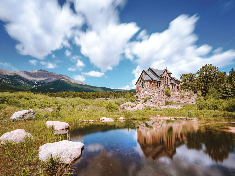
Chances are you won’t even need a recharge to tackle the state’s first designated scenic byway. (But don’t worry, there are Level 3 chargers near both ends in Idaho Springs and Estes Park.) Pick up the byway in Black Hawk on CO 119 and head north to the Hessie trailhead. It’s a perennial favorite for fall foliage, so instead of fighting the hordes for a parking spot, plug into the Level 2 charger at Nederland High School, where a free shuttle will take you to the trailhead on summer weekends. Back in the car, take CO 72 through Nederland and Ward, then CO 7 to Estes Park. Popular leaf-peeping stops along the way include the glacially carved Brainard Lake Recreation Area and Saint Catherine of Siena Chapel, but don’t miss the aspens around Lily Lake, says John Berry, a staff photographer with Visit Estes Park. “You can walk around the entire lake in 20 minutes, and there are paths that wind higher up the surrounding mountains,” he says. After some smoked pheasant chowder at Estes’ Bird & Jim, you can head back to Denver or take Trail Ridge Road (another EV-friendly byway) through Rocky Mountain National Park.
Grand Mesa Scenic Byway
Round-Trip From Denver: 580 miles
CO² Emitted: 70 kilograms EV; 238 kilograms gas

You can spend as much time eyeing the water as you do the aspens along the 63-mile Grand Mesa scenic byway: The world’s largest flat-topped mountain is home to more than 300 lakes. Depending on your mileage, however, you’ll probably want to head into Grand Junction before doubling back on I-70 to CO 65 and the start of the byway. The closest fast chargers to the route’s start are in the city, including one at Mesa County Central Library. (If you’d rather consume elevated Mexican fare than the written word while you wait, it’s a short walk down North Fifth Street to the rotating, Grand Valley–sourced menu at Tacoparty.) On the byway, the prime aspen zone is between 9,000 and 10,000 feet. Many of the area’s hiking trails are higher up in the coniferous forests, so some of your best bets for seeing color on two feet are taking the chairlift up Powderhorn Mountain Resort (where there’s a Level 2 Tesla plug) and the Mesa Lakes Recreation Area ($5 fee), where aspens and spruce mingle on the shoreline. To get out on the water, Mesa Lakes Lodge rents rowboats, canoes, and paddleboards for $45 a day. It also has a full bar, a restaurant, and cabins if you need a spot to lay your head (from $140 per night). Farther south, families with young children or those with mobility challenges will enjoy the half-mile, paved, and aptly named Land of Lakes Trail, which overlooks 144-acre Island Lake, the region’s largest. Whatever body of water you enjoy, however, do yourself a favor and pack plenty of bug spray.
Top Of The Rockies Scenic Byway
Round-Trip From Denver: 357 to 390 miles
CO² Emitted: 43 to 47 kilograms EV; 146 to 160 kilograms gas

Start this 115-mile route in Aspen and bring an e-bike: That way you can cycle the 11 miles up Maroon Creek Road to the Maroon Bells as you recharge your EV at the free Level 2 plugs in the Aspen Highlands Parking Garage. The road is closed to private vehicles from 8 a.m. to 5 p.m. during peak season, so your only company will be other cyclists, the occasional shuttle bus, and the nearly continuous aspen groves. Once you’re back at your car, be sure to grab picnic supplies—including French Brie, Spanish chorizo, and Colorado pickles—from the Meat & Cheese Restaurant and Farm Shop on East Hopkins Avenue as you head out of town on CO 82 toward 12,095-foot Independence Pass. From there, it’s pretty much golden aspens all the way up to 10,500 feet, says Karin Teague, director of the nonprofit Independence Pass Foundation, which helps protect its namesake region. “Then you drive by all these wetlands,” she says, “and there’s all kinds of willows and things that turn a really glorious gold, red, and yellow.” It’s more of the same on the other side of the ridge down to the town of Twin Lakes, though in Teague’s experience, the aspens east of the pass change color a little earlier than those to the west. If you need more juice before heading north on one of the byway’s two spurs—U.S. 24 to Minturn or CO 91 to Copper Mountain—there’s a fast charger in Leadville across the street from the Tabor Opera House and right around the block from the beloved High Mountain Pies pizzeria. Or you can play a round of disc golf: There’s a Level 2 charger right next to the course at Colorado Mountain College.


