The Local newsletter is your free, daily guide to life in Colorado. For locals, by locals.
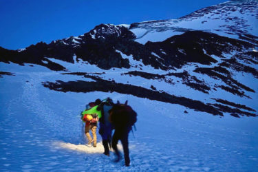
Autumn Bair had traveled the 12-and-a-half-mile stretch of I-70 through Glenwood Canyon hundreds of times, but this trip had her gripping her steering wheel so tightly her hands hurt. It was the night of July 29, 2021, and Bair had just left Valley View Hospital in Glenwood Springs, where the 39-year-old works as a part-time labor and delivery nurse. She’d been visiting a friend who’d just given birth and was late getting home. Bair called her husband, Jim, to tell him she was on her way to the family’s ranch east of the city. It had been raining off and on for more than five hours, and flooding was a real possibility. Bair hoped the interstate wasn’t closed.
Like everyone who lives in the area, Bair knew the havoc bad weather could cause inside the 2,000-foot-deep canyon. A shutdown on I-70 could turn an easy commute into a 90-minute nightmare over two-lane, high-elevation Cottonwood Pass. Bair looked at the time on her phone: It was almost 9 p.m. She needed to get home—now.

Barely five miles into the drive, Bair was already questioning her decision to leave work. Her Volkswagen Passat passed semitrucks crawling along in the right lane, their distorted emergency blinkers flashing prismatically through the raindrops that pounded her windshield.

The canyon walls reached high above the road, a rain-slickened, two-tiered ribbon of highway and bridges. In the daylight, this would likely rank as one of the most beautiful drives in America. In the rain, Bair felt like a bowling ball hurtling blindly down a lane. She fixed her mind on the Hanging Lake Tunnel, a few miles ahead. After 13 years of living on a ranch in the canyon, she knew weather often changed on the other side of the passage. Maybe things would get better.
She reached the west end of the tunnel about 20 minutes later. Two more miles, she thought to herself. Two more miles and she’d be back with her husband and their four kids.
When Bair exited the tunnel’s east end, sheets of water hammered her windshield. She couldn’t remember seeing rain this hard; her wipers couldn’t keep up. There were only a few headlights and brake lights in the distance. She was one of the only people on this strip of interstate.
Bair was passing a ravine in the canyon wall when her headlights caught some movement to her left. A wave of dark sludge cascaded over the concrete barrier that divided the interstate. Bair heard herself scream. She felt a thud on her Volkswagen’s door, and the windshield went black. She was sure Glenwood Canyon was about to kill her.
There are 46,876 miles of interstate highway in America. Among the national web of asphalt, concrete, and steel that connects us, the 66,000-foot stretch of I-70 that runs through Glenwood Canyon stands out both for its aesthetic beauty and environmental fragility. At a time when more Americans than ever are wrestling with the concept of climate change and its impacts on the planet, this piece of pavement has become ecological proof that something has gone terribly wrong.
This part of the highway, completed 30 years ago this month, was the final section of the original federal interstate system. Beyond being a neat answer at bar trivia nights, the section of highway is a linchpin in I-70’s 2,153 miles, which run from Utah to Maryland—an east-west path through the country’s midsection. Every day, more than 22,000 semitruck drivers, soccer moms, and workaday warriors zip between Glenwood Canyon’s rock walls. They shoot across bridges, glide alongside the churning Colorado River, and blast in and out of a concrete tunnel.
The canyon is a veritable what’s what of geologic history—an encyclopedia of ancient earth movements, volcanic flows, and early animal and plant life. The space the canyon occupies today has been home to Cambrian seas, Pleistocene land formations, dinosaurs, and speeding teenagers in four-wheel drives. On a clear day, millions of years of Earth’s history can slip past a windshield in just 15 minutes.
The first human trails inside Glenwood Canyon were likely created by the Ute people, who began hunting there some 700 years ago. The first wagon road was carved in 1880, followed in 1902 by Taylor State Road—a narrow dirt-and-rock thoroughfare that consisted of steep embankments that dropped directly down to the river. Even in the road’s primitive state, its namesake, U.S. Senator Edward Taylor, imagined it becoming “a portion of a national boulevard stretching across the nation.”
Incremental improvements were made to the road over the next half-century, culminating with the inclusion of newly expanded U.S. 6 in 1937. The two-lane highway provided a more reliable route to the Utah border but was still treacherous and inefficient: Drivers often pulled off the road to take in the scenery, and head-on collisions that sent vehicles tumbling into the Colorado River were frequent and often deadly.

The section of I-70 through Glenwood Canyon is something entirely different. “As far as blending a transportation project with its natural environment, it would be hard to find something that can rival the effort we see in the canyon,” says Dianna Litvak, a senior historian for architecture and construction firm Mead & Hunt who has studied the interstate for the Colorado Department of Transportation (CDOT). “It’s really a marvel.”
Today, that marvel is facing an imminent environmental crisis. As wildfires and severe flooding have plagued swaths of the West over the years, there may be no place where the effects have been seen as starkly as they have been in Glenwood Canyon. The changes have been swift and violent: The August 2020 Grizzly Creek fire burned in the canyon for four months, consumed an area roughly a third of the size of Denver, and caused more than $34 million in damage across one of the state’s most vulnerable ecological areas.
Seven months later, heavy rain pummeled the burn scar, sending a wave of debris across the highway that damaged Hanging Lake Tunnel, blasted holes through asphalt, and altered the Colorado River’s flow in one section. The total cost to repair the interstate so far has exceeded $110 million—or roughly one-seventh of this part of I-70’s original construction cost in today’s dollars. “It’s mind-boggling to witness what’s happening here in such a short time,” says Ralph Trapani, the project manager who oversaw the I-70 enterprise in the canyon over portions of two decades and lives in Glenwood Springs. In the 1980s, Trapani’s team pulled rock cores from a site on the eastern side of the canyon, which provided them with a historical record of the events that changed the land’s composition over time. “There were 20,000 years in one core,” Trapani says. “In those 20,000 years, we didn’t see anything as abrupt as what’s happened in the canyon in these past two years.”
Throughout the West, costs related to climate change have increased—at times exponentially—over the past couple of decades. The National Oceanic and Atmospheric Administration estimates that costs from catastrophic environmental events (such as flooding, wildfires, and drought) alone totaled $47 billion from Colorado to California in 2021—an increase of $23.6 billion from the previous year. The total damage between 2016 and 2021 was estimated at $138.4 billion, or more than two-thirds of the overall disaster costs for the previous 36 years combined.
Early this summer, I met Paul Chinowsky, an emeritus professor of civil engineering at the University of Colorado Boulder who’d spent most of his career studying infrastructure, with an emphasis on transportation. Four years ago, he co-wrote a chapter on the impacts of rapidly changing environments on America’s major roadways as part of a project for the U.S. Environmental Protection Agency. Chinowsky explains that the canyon’s “whiplash events” of fire and flood had clearly devastated the area, but focusing on their suddenness was missing the point. “For most people, this feels like the switch was flipped overnight, but that’s not true,” he says. In fact, the table was quietly being set for decades.
The professor drew a crude, two-dimensional rendering of the canyon wall leading down to the interstate. Under normal circumstances, Chinowsky says, rock fissures slowly freeze and thaw, a process that eases the canyon into seasonal changes. In the past 20 or so years, the cycle has been different. As weather has become more unpredictable, extreme heat and precipitation have become more commonplace. Following a cold winter snowstorm, for example, the canyon wall quickly freezes. But a rapid weather shift, fueled by climate change, can bring an equally fast thaw, followed, again, by another fast freeze, and so on and so on. “The fissures eventually expand at a rate that’s unsustainable. Then, you pile fire and severe rain on top of that, and what do you expect might happen?” Chinowsky says. The answer is the potential for severe rockfall or a major debris slide, the likes of which we are only beginning to see. “There’s catastrophic failure,” Chinowsky added. “I don’t even think we’ve seen the worst of what can happen in that canyon.”
To see things for myself, I drove a winding dirt road into White River National Forest to get a better look at the origins of last year’s disaster. It was early June, and several trails were still closed from the devastation. I found an open four-wheel-drive road that ran south from an abandoned campground situated far above the interstate. It had rained heavily the day before, and broken tree limbs were scattered everywhere. I got out of my vehicle and hiked seven miles toward the 2020 wildfire’s burn scar.
I crossed a small creek and zigzagged through the burned area. Roughly two miles from Grizzly Creek, the entire forest had turned to charcoal. The damp ground looked like a burnt croissant, black and flaky. I took a step on a slope and fell. The ground peeled away, leaving a smear of brown mud in the otherwise charred earth. I looked up at the pine trees that were still standing. There were hundreds of them—barren, scorched limbs reaching 50 feet or more toward the blue sky.
Being here, I had no difficulty imagining the events that led to the previous year’s calamity. The burned earth was about as porous as a city sidewalk, and it drained into a valley that led directly to the 2,000-foot drop-off above the interstate. The debris slide began with one raindrop that was followed by trillions more. Gravity did the rest. Dirt and small rocks were loosened by the runoff first. Dead trees eventually were torn from the earth. One boulder gave way, then another; the massive rocks hurtled down the canyon wall at speeds of up to 40 miles per hour.
On that night in July 2021, Jeff Colton was working an extended shift at the National Weather Service’s Grand Junction office. The five-room brick building at the airport is the nerve center for weather tracking in western Colorado and eastern Utah. It’s also become the front line for early flood detection in some of the nation’s most ravaged wildfire areas. At around 5 p.m., Colton and another meteorologist were watching their computer screens for small storms popping up across more than 50,000 square miles of the Mountain West.
Colton, who helps lead weather-warning coordination and is one of the office’s incident meteorologists, was tracking a rainstorm that had developed over Glenwood Canyon. It was serious enough to warrant a flood warning—protocol that cleared trails and bike paths and gave CDOT ample notice that a bigger event might be forthcoming. A couple of hours later, though, the storm didn’t look like the deluge Colton’s colleagues had anticipated. The warning was canceled, and a third meteorologist was sent home. Colton assumed he’d settle into a typical night watching weather from the three screens on his desk.
At around 8:30 p.m., a red streak suddenly appeared on radar just north of I-70 on the eastern third of Glenwood Canyon. A few minutes later, text messages began blowing up Colton’s phone. The pings were automated alerts from five rain gauges in and around the Grizzly Creek burn scar. The gauges had been placed there a couple of months earlier—about the same time the National Weather Service and CDOT came up with a plan that dictated a domino weather-emergency reaction that began with hiking trail closures and ended with an I-70 shutdown.
The instigator was precipitation. Two-tenths of an inch of rain within 15 minutes and Colton would have to consider issuing a flash-flood emergency—which would likely close the interstate. It wasn’t an easy call. The meteorologists in the Grand Junction office were schooled on the impacts of their decisions: One hour without I-70 traffic equaled $1 million in lost economic output to the nation.
Colton turned his attention to Cinnamon Creek, above Hanging Lake Tunnel. In five minutes, the volume of rain there was already surpassing flood-warning levels. More texts came in—from near Dead Horse Creek to the north, then from other points around the scar. Rain on the burn area was now on track to hit six inches in one hour—seven times more than the closure threshold.
These numbers can’t be right, Colton thought. He needed to issue a flood emergency. He pulled up video from CDOT cameras near the tunnel and watched as rain pummeled the road. Colton picked up his office phone and dialed CDOT engineers at the tunnel: The section of highway through the canyon needed to be shut down immediately.

Nearly a year later, Colton wanted to see the land before monsoon season began. We met at the I-70 exit at Grizzly Creek, and he looked up at the canyon’s rocky northern face. It had been months since he’d been here, and he hoped to see some signs of rejuvenation—namely, lush green above places where debris flows had started the previous year. Instead, he saw huge areas of brown, broken up by a patchwork of anemic green. “It’s like there’s no improvement at all,” he told me. I showed him photos of my hike above the canyon a few weeks earlier, and he asked me to zoom in on images of the burn scar. He turned to me: “That is very, very bad.”
In and near the canyon, there was omnipresent concern among residents—about fire, flood, emergency management, transportation flow, water supplies, and the funding that could potentially fix some of the environmental issues. In New Castle, 13 miles west of Glenwood Springs, roughly half of the community’s water supply comes from the Colorado River, which was still gummed up with silt and debris. New Castle recently spent nearly $2 million on water filters that were supposed to last at least two years but survived only six months. (Those new filters were already on track for early replacement.)
In Glenwood Springs, things weren’t any better. This past summer, then city manager Debra Figueroa gestured to the landscape that could be seen from her office window. Glenwood Springs had long relied on snowmelt from the spot she was pointing to for much of its water supply. Now, 22 months after the fire, the once-pure water resembled something from a half-flushed toilet. “It’s absolutely disgusting,” says Figueroa, who was Glenwood Springs’ city manager for six years until she left her post in July. “We’ve basically got pure water passing through mud.”
Nearly $9 million in state and federal money has been allocated to fund improvements to the city’s water system over the past two years, and residential and commercial water bills have recently climbed 36 percent. “We are at the forefront of climate change,” she says. “With fire and debris and our water system and our main transportation [thoroughfare] being impacted, you name it, and we’ve seen it. This is definitely a crisis.”
Chinowsky, the former CU professor, estimates extreme storms and significant environmental changes will result in $21 billion in damage annually to major roadways nationwide. “We see fire and debris in consecutive years in Glenwood Canyon, but we’re not even close to a worst-case scenario,” he says. “When we get to that point, and nothing significant has been done, a lot of people are going to get hurt or die.”
In March of this year, more than 100 stakeholders met in Glenwood Springs to game-plan for potential disaster scenarios that could affect Glenwood Canyon. Among the participants were the U.S. Department of Homeland Security, CDOT, local municipalities, police and fire departments, civil engineers, local hospitals, and even Google—which wanted input on how to improve its real-time mapping system to handle large-scale emergencies. People who attended the meeting said they came away confident about the cooperation among the organizations. But there was also disappointment that a silver bullet solution didn’t exist to prevent future disasters on the interstate.
Following the 2021 slide, Governor Jared Polis applied for immediate federal relief, and more than $32 million has been put into repairs and improvements ($22 million from the federal government). The rehabilitation is ongoing: This summer, CDOT was placing super sacks—white bags that resemble enormous marshmallows that can catch debris before it hits the road—at the terminus of some of the canyon’s most worrisome gulches. Last fall, the department finished repairing a stretch of polyester-reinforced concrete, which is designed to be stronger and more durable than standard concrete, that had been badly damaged at Blue Gulch, where the worst of the debris slide occurred.
CDOT contractors have begun installing rectangular, rock-filled wire cages adjacent to the interstate to contain mud and rock, and road crews upped the frequency with which they pull fallen rocks and other debris out of culverts. CDOT has estimated that the cost for these basic reconstruction and maintenance projects will total nearly $10 million. CDOT’s plans for Cottonwood Pass—the best alternate route in the event of a canyon closure—are underway but still have significant municipal hurdles to clear. On top of that, Glenwood Springs was completing the design of a $53 million bridge project this fall to help ease traffic during emergency evacuations, and city engineers were talking to CDOT about creating a series of access-line breaks along I-70 west of the city that could open and funnel traffic during a life-threatening disaster.
The fixes, however, can feel like Band-Aids on a terminal patient, and Figueroa often finds herself imagining the next disaster. “I’m thinking about worst-case scenarios all the time,” she says. Last year, as the debris slides were being cleaned up on the canyon’s eastern half, the threat of a small fire on the west end came about because of increased activity at a long-burning coal seam. Fortunately, mountain passes were untouched, and traffic was able to get out of the canyon.
“But what about the next time?” Figueroa says. “What if those alternate routes are compromised and we have hundreds of people trapped on the interstate? You don’t want to think about it, but you have to. These past couple of years have shown us that the unthinkable has now become a possibility.”
Two miles east of the city, Trapani, the engineer, was waiting at the No Name rest area. He was eager to show me the interstate through his eyes, with all its triumphs and challenges. Before we got into his Audi, we climbed a concrete walkway overlooking a curve in the interstate. Trapani pointed to the inner edge, where engineers had backfilled a portion of old U.S. 6 decades before. What once was an unsightly scar on the landscape now looked as natural as if it had been there for a thousand years. “We completely changed a part of this canyon that had been absolutely ravaged” by previous construction work, he told me.

Trapani has lived in Glenwood Springs for 47 years, which means he’s constantly seeing his handiwork. When we pulled onto the interstate, he pointed out individual trees that were relocated during construction. He showed me rock faces that had been blasted and then stained to look as if they’d been exposed for ages. He spotted some oak brush and remembered the day the shrubs were planted. Trapani kept his car in the far right lane, a position he was unaccustomed to on this stretch of highway. He admitted he likes traveling the canyon at high speeds, hugging turns as if he were racing in the Swiss Alps. That sentiment was reinforced by the squawks from the radar detector on his dash. Going fast, he told me, is “a great way to feel the work we did here.”
We came upon the opening for Grizzly Creek, which looked like a spillway more than anything else. The worst of the slide was still visible: Large, chunky rocks and broken tree trunks pushed down the canyon wall to the Colorado River. Trapani had recently taken a ride along the bike path that runs parallel to the interstate and marveled at how the debris had changed a portion of the river.
When he’d set foot in the canyon as project manager in 1980, there were questions about the geology of the place—and misconceptions about what was hidden inside the earth. His team discovered tremendous amounts of buried talus, which created a crumbling, chalklike layer that extended more than 50 feet deep in some parts. (A slurry was pumped into the ground in places to harden it and make it suitable to anchor bridge pillars.) “Rockfall was what we thought about,” Trapani says.
During projects, it’s common for engineers to look at 30-year weather patterns to determine future environmental impacts. That process now feels outdated. “Climate change wasn’t even part of our language then,” Trapani adds. “How do you plan for that when you didn’t even realize it was happening?” Now, this strip—his strip—of interstate was turning 30 years old. “We planned for absolutely everything that could have been considered at the time,” he says.
We reached Hanging Lake Tunnel. Its 1,400 yards of concrete make up the first interstate tunnel in America built without metal ribs holding up the midsection—Trapani’s pièce de résistance. He let out a giddy yelp as his car disappeared into the concrete tube. “I would have built this thing for free,” he says. We pushed out the other end, and I thought about Autumn Bair and how she’d come out of this same tunnel and let loose a scream of fear.
Trapani was 28 when he took the project manager job. He’s now 70 with an adult son and has more time to reflect on the work he’s done over his career. On his bike trip a week earlier, he’d taken his partner to a rest area near the tunnel, for which he’d overseen the design. Not long ago, the table was buried under several feet of mud. “How the hell did this survive?” he wondered aloud. “Solid build?” his partner replied.

It was a common theme that day, Trapani says, stopping at different sections and marveling at their survival. Yes, bridge decks were significantly damaged in certain areas, but the bridge piers were unharmed. “You think of these massive boulders and trees just rumbling down the canyon wall and what would have happened if they’d wiped out those footings,” he says. Trapani came away content with the work, saying, “We did the best job we could have done. No regrets.”
Back at the No Name rest stop, he turned off the car’s engine and sat for a moment. The I-70 job took 12 years of his life. Thirty years after its completion, he wonders what might exist here in the next 30 years. “Like they say,” Trapani says, “Mother Nature bats last.”
When she allows herself to remember, Autumn Bair can still hear and feel everything from that July night: the sound of debris hitting her driver’s door; the flash of muck over the windshield; the silence that followed. She’d had to crack her door open and pull herself out. Her adrenaline surging, Bair’s fingers shook so much she couldn’t call her husband. Mud was still oozing down the canyon’s north face. Lightning flashed every 15 seconds. Bair put her phone in her shirt and ran a mile and a half home in the rain.
Nearly a year later, Bair is on the phone talking about the lessons she learned about herself—chief among them that she would do whatever she needed to see her family again. She also learned she could manage panic, that she could make split-second decisions and live with them. Bair told me she’d been criticized by locals, people who said she should have stayed in her car and waited for the police or fire department to help—that she unnecessarily endangered her life when she ran home with God knows what awaiting her on the interstate.
She never thought about her escape that way. “It was either sit in the car and get buried or run toward home and maybe get hit by falling rock on the way,” Bair says. She pauses for a moment, as if she can’t believe the macabre equation that had run through her head that night: What was the better way for a mother of four to go? “I wasn’t about to be buried alive,” she says. “Get hit by a rock and maybe my death would have been quick.”
As we talked, Little Blue, her 17-year-old Volkswagen, was parked out front. Some friends from the Gypsum Fire Department pulled it out the day after Bair abandoned the car. She and her husband watched as the men dug out the vehicle, which was buried in waist-high mud. When the fire chief told her there’d been an even worse slide a couple of miles behind this one, she cried.
The insurance company declared the Passat totaled, but Bair couldn’t give it up. Dried mud was caked over every square inch when it was towed back to the ranch. Nearly a year later, the car ran most of the time. When Bair took it in for a repair recently, mechanics pulled more dirt out of the engine.
The debris slide was, in fact, the second time she’d been forced to abandon Little Blue in the past two years. During the 2020 canyon fire, Bair got a call from a Garfield County deputy, telling her that flames were heading toward her house. The family had roughly 24 hours to evacuate. The interstate was closed, so Bair rushed home from the hospital via Cottonwood Pass. She made it to a point a couple of miles above her property when the road became dangerous. She abandoned the Passat and ran the rest of the way. “A familiar story,” she says today.
Despite feeling like something strange and unnerving is going on in the canyon, Bair hasn’t entertained the idea of moving. Her husband’s family came here in the early 1900s as sheepherders in cowboy country, risking their lives in the process. There’d been the Great Depression and recessions and drought. Even after all she’d been through in the past two years, Bair tried to put it in perspective. She was grateful the kids hadn’t been with her that night on the interstate; she was relieved fire hadn’t ruined everything her husband’s family had built on the ranch; and she was happy to wake up every morning in one of the most gorgeous settings in one of the country’s most gorgeous states.
She knew July would bring scorching temperatures. A small wildfire had recently popped up near the ranch. Although the flames were quickly extinguished, the event made Bair wonder what the rest of the summer would look like. How bad might the rain get in August? The land had never felt so fragile. “I guess that’s the life you choose when you live here,” she said. “You’re always thinking about what might happen next.”